Why the name Zanzibar?

zanzibar2
Map of Tanzania including Zanzibar (Wikipedia)

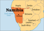
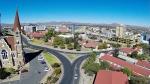
Zanzibar is one of the main archipelago of Tanzania, and actually the name Tanzania comes from combining the names Tanganyika and Zanzibar. It is situated on the Swahili Coast, adjacent to Tanganyika (mainland Tanzania). Located in the Indian Ocean, Zanzibar consists of many small islands and two large ones: Unguja (the main island, referred to informally as Zanzibar) and Pemba. The capital is Zanzibar City, located on the island of Unguja. Its historic center, Stone Town, is a World Heritage Site. So why the name Zanzibar?

The name Zanzibar comes from the Arabic Zanjibār (زنجبار), which in turn comes from the Persian Zang-bār (زنگبار), a compound of Zang (زنگ, “Black“) + bār (بار, “coast, land, country“), name given by Persian navigators when they visited the area in the middle ages. So, in essence, Zanzibar means the “land of the Blacks” or “the land of the Black people,” or “the coast where Black people live.”

Cloves1
Cloves

Traders from the Arabian Peninsula, the Persian Gulf region of modern-day Iran (especially Shiraz), and west India probably visited Zanzibar as early as the 1st century. Zanzibar was used as a base for voyages between the Middle East, India, and Africa. In the olden days, the archipelago was known as Spice islands, and was world famous for its cloves (see the article I wrote So much for that clove in your food!) and other spices.

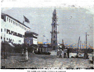
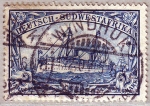
Vasco da Gama‘s visit in 1498 marked the beginning of European influence. In 1503 or 1504, Zanzibar became part of the Portuguese Empire. Zanzibar remained a possession of Portugal for almost two centuries. In 1698, Zanzibar fell under the control of the Sultanate of Oman. In 1832, or 1840, Said bin Sultan moved his capital from Muscat, Oman to Stone Town in Zanzibar City.

zanzibar-slave-market
Zanzibar slave market

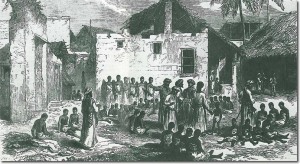
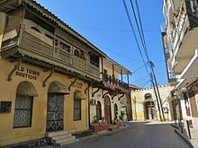
Malindi in Zanzibar City was the Swahili Coast’s main port for the slave trade with the Middle East. In the mid-19th century, as many as 50,000 slaves passed annually through the port. Many became rich through the slave trade, such as the notorious Arab slave trader and ivory merchant, Tippu Tib. Today, there are still vestiges of old slave forts in Stone Town.

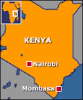
Until around 1890, the sultans of Zanzibar controlled a substantial portion of the Swahili Coast, known as Zanj, which included Mombasa and Dar es Salaam. Beginning in 1886, Great Britain and Germany plotted to obtain parts of the Zanzibar sultanate for their own empires. Over the next few years, however, almost all of these mainland possessions were lost to European imperial powers.

zanzibar-sultan_sayyid-abd-allah-ibn-khalifa-1910-1963
Sultan Sayyid Abd Allah ibn Khalifa

In 1890 Zanzibar became a protectorate (not a colony) of Britain. This status meant it continued to be under the sovereignty of the Sultan of Zanzibar. From 1890 to 1913, traditional viziers were in charge; they were supervised by advisors appointed by the Colonial Office. However, in 1913 a switch was made to a system of direct rule through British governors. The death of the pro-British Sultan Hamad bin Thuwaini on 25 August 1896 and the succession of Sultan Khalid bin Barghash, whom the British did not approve of, led to the Anglo-Zanzibar War, known as the shortest war in history lasting 38 minutes.

zanzibar_the_harem_and_tower_harbour_of_zanzibar_1890
The Harem and tower harbor of Zanzibar ca 1890

On 10 December 1963, the Protectorate that had existed over Zanzibar since 1890 was terminated by the United Kingdom. The United Kingdom did not grant Zanzibar independence, as such, because the UK had never had sovereignty over Zanzibar. Rather, by the Zanzibar Act 1963 of the United Kingdom, the UK ended the Protectorate and made provision for full self-government in Zanzibar as an independent country within the Commonwealth. Upon the Protectorate being abolished, Zanzibar became a constitutional monarchy under the Sultan. However, just a month later, on 12 January 1964 Sultan Jamshid bin Abdullah was deposed during the Zanzibar Revolution. The Sultan fled into exile, and the Sultanate was replaced by the People’s Republic of Zanzibar and Pemba. In April 1964, the republic merged with mainland Tanganyika. This United Republic of Tanganyika and Zanzibar was soon renamed, blending the two names, as the United Republic of Tanzania, within which Zanzibar remains a semi-autonomous region.

zanzibar1
Beach of Zanzibar (Zanzibar.net)

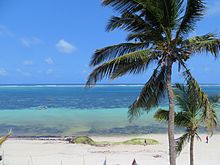
Today, Zanzibar is world-renowned for its great tourism, with Stone town showing remnants of the ancient Swahili kingdom, and the melting pot of cultures (Persian, Arabic, Bantus, European), and its cloves. Enjoy the video below, and whenever you visit Zanzibar, remember that it is the Land of the Black people!

Why the Name: Alexandria?

alexandria_-_egypt
View of the Corniche of Alexandria (Wikipedia)

It is about time we talked about Alexandria, the light of Egypt. So why the name Alexandria? If you thought about Alexander the Great, then you are absolutely right! Yes. The second largest city and major economic center of Egypt was named and founded by Alexander the Great.

alexander-the-great
3rd century BC bust of Alexander the Great (Wikipedia)

Alexandria was founded around a small Ancient Egyptian town around 331 BC by Alexander the Great. It became an important center of the Hellenistic civilization and remained the capital of Hellenistic and Roman and Byzantine Egypt for almost 1000 years until the Muslim conquest of Egypt in AD 641, when a new capital was founded at Fustat (later absorbed into Cairo). Hellenistic Alexandria was best known for the Lighthouse of Alexandria (Pharos), one of the Seven Wonders of the Ancient World; its Great Library (the largest in the ancient world; now replaced by a modern one); and the Necropolis, one of the Seven Wonders of the Middle Ages. Alexandria was the second most powerful city of the ancient world after Rome. Ongoing maritime archaeology in the harbor of Alexandria, which began in 1994, is revealing details of Alexandria both before the arrival of Alexander, when a city named Rhacotis existed there, and during the Ptolemaic dynasty.

alexandria_library
The Great Library of Alexandria

To me, Alexandria, has always had a special place in my heart because of its Great Library. Imagine thousands upon thousands of ancient papyri, scrolls, and books on mathematics, philosophy, medicine, architecture, etc. Just the thought of it makes my eyes shine with light. Isn’t it thrilling? And then to know that this library had been burnt down by the army of Julius Caesar in 48 BC (more like a repeat of history: Palmyra, The giant Buddhas of Afghanistan, Timbuktu, …) also makes my heart ache at the thought of all this knowledge gone down in flames. Today, we remember the Great Library of Alexandria thanks to what poets and writers of the past said about it, but there are no vestiges of it. I also remember Alexandria because of the brilliant female mathematician Hypatia who chaired a department of philosophy and astronomy, and the world-renowned mathematician Euclid.

Today, Alexandria is Egypt’s largest seaport, serving approximately 80% of Egypt’s imports and exports. It is an important industrial center because of its natural gas and oil pipelines from Suez. Alexandria is also an important tourist destination. Enjoy the video below about Alexandria, the beautiful!

Why the Name: Accra?

ghana_mapAs a child, I often thought of how cool the name of the capital of
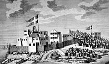
 Ghana, Accra, sounded. My aunt however, told me that it meant ‘beignets‘ in some West African language, and that could not possibly be beautiful. See how funny some words in one’s language could mean something totally different in another. That made me curious to find out about the real meaning of Accra. Well, it is not even in the local language, but rather is a European “deformation”. The main Ga group known as the Tumgwa We led by Ayi Kushie arrived by sea. When the Lartehs of the coast saw them on their canoes at sea, they thought they looked like ants, and thus called them Nkran or ants. Nkran was later deformed by the Danes to Akra, then to present-day Accra. Well, as a fun note, the feeling of an ant walking on one’s skin could make one scream “Aaaaaah Krrrrraaaa”!

ghana_fort-christianborg_-now-osu-castle
Christiansborg (now Osu Castle) in the 1700s, site of Accra

Jokes aside, originally, Accra was not the most prominent trading center in the country. However, the Dutch built the nearby outposts of Ussher Fort while the British and Swedes built James Fort and Christiansborg castles respectively. By the 17th century, Portugal, France, and Denmark had built forts in the city. As a side, did you know Denmark had been involved in the slave trade? Dutch and Swedes too? The Swedes… in the slave trade along the African coast? For the longest time, I thought the slave trade had only been a Portuguese, British and French affair. So today, the scramble for Africa with the European union, America, China, India, etc… is just a repeat of a 16th – 17th centuries’ history!


accra_main-street-c1885-1908
Main street in Accra between ca 1885-1908

Britain gradually acquired the interests of all other countries beginning in 1851, when Denmark sold Christiansborg (which they had acquired from the Swedes) and their other forts to the British. The Netherlands was the last to sell out, in 1871. In 1873, after decades of tension between the British and Ashantis of the peninsula country Ashantiland, the British attacked and virtually destroyed Ashantiland and Ashanti Region capital of Kumasi. The British then captured Accra in 1874, and in 1877, at the end of the second Anglo-Asante War, Accra replaced Cape Coast as the capital of the British Gold Coast. This decision was made because Accra had a drier climate relative to Cape Coast.


As the newly established Gold Coast’s administrative functions were moved to Accra (1877), an influx of British colonial administrators and settlers grew around Christiansborg (modern Osu, Ministries, Ridge, Labone, and Cantonments), and the city expanded to accommodate the new residents. Victoriaborg was formed in the late 19th century as an exclusively European residential neighborhood, located to the east of the city limits of the time. The boundaries of Accra were further stretched in 1908. This expansion entailed the creation of a native-only neighborhood. Adabraka was thus established to the north of the city.

ghana_aerial-view-accra-7-nov-1929
Aerial view of Accra in 1929

In 1908, the decision was made to build the Accra-Kumasi railway to connect the country’s port with the main cocoa-producing regions. In 1923, the railway was completed, and by 1924, cocoa was Ghana’s largest export.


The modern city of Accra is centered on the original British, Danish, and Dutch forts and their surrounding communities: Jamestown near the British James Fort, Osu near the Danish fort of Christiansborg (now Osu Castle), and Ussherstown near the Dutch Ussher fort.

accra_kwame-nkrumah-memorial2
Kwame Nkrumah Memorial in Accra

Tourist attractions include the National Museum of Ghana, the Ghana Academy of Arts and Sciences, the National Archives of Ghana and Ghana’s central library, the National Theatre, the Accra Centre for National Culture, the Jamestown lighthouse, and the Ohene Djan Stadium. The city is also a transportation hub, home to the Kotoka International Airport, and railway links to Tema, Sekondi-Takoradi and Kumasi.


Today, Accra is one of the biggest hubs in West Africa and on the African continent. It is also a place of pilgrimage to many people of African descents trying to retrace their past: African Americans, Afro Brazilians, especially due to the great numbers of slavery forts in the city and country, but also because of the work of W.E.B. Du Bois. Well, if you are ever in Accra, visit, enjoy it, and feel Ghana! The video below will make you want to go there.


Why the Name: Malabo?

Malabo7
View of Malabo (3rdWorldProfashional.com)

How many Spanish cities do you know have a British heritage? How many do you know were named after English kings? How many cities do you know have had three different names in their history? Malabo, the capital of the Equatorial Guinea is such a city.

Since its origin, Malabo has been known by three different names: Port Clarence or Clarence City from 1827 to 1846 under British occupation; Santa Isabel from 1846 to 1973, under Spanish occupation; and Malabo since 1973 as the capital of the independent country of Equatorial Guinea.

Malabo is located on the northern part of the island of Bioko (island previously known as Fernando Po), 32 km from the coasts of Cameroon. Similar to the island of La Réunion, the island of Bioko is volcanic with its mountain Pico Basile towering at 3000 m, which can be seen from Limbe in Cameroon on a clear day.

Malabo4In 1472, in an attempt to find a new route to India, the Portuguese navigator Fernão do Pó, discovered the island of Bioko, which he called “Fermosa“. Later the island was named after its discoverer, Fernando Poo. In 1507, the Portuguese Ramos de Esquivel made a first attempt at colonization on the island of Fernando Poo. He established a factory in Concepción (currently Riaba) and developed plantations of sugarcane, but the hostility of the insular Bubis people and diseases ended this experience quickly.

With the treaties of San Ildefonso in 1777 and El Pardo in 1778, the Portuguese gave to the Spanish the island of Fernando Poo, Annobon, and the right to conduct trade in the mainland, an area of influence approximately of 800,000 km² in Africa, in exchange for the Colonia del Sacramento in the River Plate and the Santa Catalina Island off the Brazilian coast.

Malabo5
Island of Annobon from the skies (3rdWorldProfashional.com)

Later, Spain lost interest in Spanish Guinea (Equatorial Guinea), and authorized the British to use the island as a base for stopping the Slave Trade (this was before the creation of Sierra Leone as a colony for freed slaves).  Thus, on 25 December 1827, Port Clarence was born on the ruins of a previous Portuguese settlement. The name was chosen in honor of the Duke of Clarence, who later became King William IV. The Bubis indigenous to the island called it “Ripotó (place of the foreigners). The city was also known as Clarence City. Descendents from freed slaves mixed in with the local Bubi tribe speaking an afro-anglo-spanish pidgin or creole called « Fernandino ».  At first the British dreamt of turning Port Clarence into a great commercial port like those of Lagos and the Cape. However, the installation into the colony was deemed too costly, and isolated. In 1845, with the abolition of slavery, the British negociated with the Spanish, and gave them back control over the city, while still maintaining a stop for their commercial ships. Spain agreed to preserve British interests and to allow free passage to British ships as well advantages, which lasted until the country’s independence in 1968. Spain even maintained the British cultural heritage, Spanish will only become majoritarily spoken around 1920.

Spain regained control of the island in 1855 and the capital Port Clarence was renamed Santa Isabel, in honor of Queen Isabel II. In 1969, one year after independence, Santa Isabel became the capital of Equatorial Guinea.

Malabo Lopelo Malabo I on Bioko 1930
King Malabo Lopelo Melaka

Its present name, Malabo, was given in 1973 by President Macías Nguema in honor of King Malabo Lopelo Melaka, the last Bubi king.

Today, Malabo is the commercial and financial center of Equatorial Guinea. The main industry of the city is fish, while cacao and coffee are the main products of export. With its recent discovery over the past decade, oil has become a big industry. Malabo has a port of high tonnage connected mainly to the ports of Douala (Cameroon) and Bata (Equatorial Guinea) and air linked via an international airport. Oil has brought in a lot of investments and development to the country and particularly to the city, which has seen tremendous growth over the past few years.

Malabo6
View of Malabo Cathedral (3rdWorldProfashional.com)

Given that Malabo is the oldest city in Equatorial Guinea, many buildings within the city are built in colonial architecture style remnants of Spanish rule, and coexist today with modern architecture. It is a mix of old and modern, with a reliable road system. In the coastal region north of the city are the bays and capes. Provisions are hard to find, given that it is an island, and the cost of living is high.


Aerial view of Malabo´s harbour
Malabo’s harbor on the island of Bioko, Equatorial Guinea (Libreville-airport.com)

With only 1,180 hours of sunshine per year, Malabo, is one of the gloomiest capitals in the world and experiences much fog even when it is not raining. So, it is a lot like London… funny that the British didn’t like it ! Enjoy reading from 3rdWorldProFashional.com and FemmeExpat.com.


Note: 27 Jun 2019 – I have amended the article, as it has been brought to my attention that image 3 is the island of Annobon and not the island of Bioko where Malabo is located. Thank you Apolonio.

Why the Name: Windhoek?

Nambia2Ever wondered what the name of the capital city of Namibia, Windhoek, mean? To me, thinking about the English beginning ‘Wind‘, I wonder if its name has something to do with wind, even though Namibia was never a British colony? However the end part ‘Hoek‘ does not sound English at all. Could the name be a European ‘deformation’ of a local name, the way Yaoundé or Abidjan are?

Windhoek_19eme siecle
Windhoek settlement at the end of the 1800s

Well, imagine my surprise when I found out that Windhoek stand for ‘wind-hoek‘ or “Wind Corner” in Afrikaans (Windhuk in German). Knowing that the country was a German colony, why will it have an Afrikaans’ name? The two languages being so close together, maybe the name was first German, and later on Afrikaans, given that the country fell under South African ‘administration’ after Germany lost first world war.  Well, it is said that the city was founded in 1844, by Captain Jonker Afrikaner who named it Windhoek after the Winterhoek Mountains at Tulbagh in South Africa, where his ancestors originated from.

Windhoek_2
Windhoek settlement at the end of the 1800s

In its history, the city of Windhoek has had at least 7 different names: “Aigams” for hot springs as named by the local nomadic Khoekhoe people; “Otjomuise” for the place of steam as named by the local Herero people; both names referring to the hot springs located near today’s city center. It was later named “Queen Adelaide’s Bath” by English explorers in 1836. Then it was named “Concordiaville” by Rhenish Missionaries. In 1840, it was named “Winterhoek” by Jonker Afrikaner and his group of Nama people who were emigrating from the Cape. It became “Windhuk” in 1890 with the German colonization of the country, and it has been “Windhoek” since 1920 under South African administration and has remained so after independence in 1990.

Windhoek_Stamp
Windhoek settlement at the end of the 1800s

Located in the Khomas Highland plateau area, in central Namibia, Windhoek stands at around 1700 m above sea level. It is the social, economic, political, industrial, and cultural center of the country. It is a bustling, growing city, and tourism is playing a big part in the city’s life as well. Enjoy the video below about Windhoek.


Why the name: Mombasa?

Mombasa_1572
Mombasa in 1572

Have you ever wondered about the origin of the name of Kenya‘s oldest and biggest port city? Why? I am talking about Mombasa of course, the coastal and beautiful city of Mombasa; the city visited by the famous Moroccan scholar and traveller Ibn Battuta in 1331, as well as the great Chinese navigator Zheng He in the 1413.

Mombasa_Moi avenue1
Moi Avenue with its tusks, Mombasa today

The earliest recorded mention of Mombasa is in the works of Diogenes, a Greek merchant in the First Century (supported by  Ptolemy). Diogenes reported that he had been blown off course from his usual route to India, ending up in a port town he called Rhapta. Rhapta has never been conclusively identified, but Roman coins have been found on several islands that were part of, or near, what became the Sultanate of Zanzibar, of which Mombasa was a core town. In 1151, the Arab geographer Al Idrisi described it as prosperous trading town. Other pioneers of maritime exploration also visited Mombasa, including the Portuguese Vasco da Gama (1498), Pedro Álvares Cabral (1500) João da Nova (1505) and Afonso de Albuquerque (1507). 16th-century Portuguese voyager Duarte Barbosa claimed, “[Mombasa] is a place of great traffic and has a good harbor in which there are always moored small craft of many kinds and also great ships,

Mombasa_old_town_view
View of Old Town Mombasa (Wikipedia)

The island was first referred to as Manbaça or Manbasa in 1502, when the Sultanate became autonomous from Kilwa Kisiwani. Manbasa is the Arabic form of the Kiswahili name, Mvita, derived from Shehe Mvita, the founding father of the island city (not sure how Mvita made it into Manbasa – another case of a foreigner playing with phonetics, i.e. not hearing well). It is also known as the “Island of Mvita.” Some sources claim that Mvita is actually derived from Mombasa’s violent history over the centuries. The history supposedly earned the city the Kiswahili nickname “Kisiwa Cha Mvita”, or the “Island of War”.

Kenya_map
Map of Kenya with Nairobi and Mombasa

Most European travelers referred to it as Mombaz or close forms of the word. While it was a British Protectorate for 2 years between 1824 and 1826, Mombasa was turned over fully to the British Imperial East African Company in 1898. The Sultan of Zanzibar officially leased the town to the British government in 1895 as a follow-up to an 1885 agreement. Mombasa became the capital of the Protectorate of Kenya sometimes between 1887 and around 1906 until Kenya’s capital was moved to Nairobi around 1906. Technically, and legally, the coastal strip that is today the Kenyan coastline remained part of Zanzibar until it was ceded to independent Kenya in 1963.

Mombasa_Nyali_Beach
Nyali beach in Mombasa (Wikipedia)

The town of Mombasa is centered on Mombasa Island, but extends to the mainland via two creeks, Port Reitz in the south, and Tudor Creek in the north. Today as always, Mombasa is a major trade center, and home to Kenya’s only large seaport. Because of its proximity to Zanzibar, Nairobi and the Indian subcontinent, Mombasa is a melting pot of diverse cultures and people. It is the center of the coastal tourism in Kenya. Enjoy this great video on Mombasa, the city of Mvita, named after its great leader and founding father.


Why the name: Memphis?

Memphis_Ramses II_1
Statue of Ramses II in Memphis (Wikipedia)

Ever wondered where the name Memphis came from? No, I am not talking about Memphis the capital of Blues in Tennessee (USA), but rather, about Memphis, Egypt, the reason why Memphis Tennessee got its name.

Well, Memphis in Egypt, was the ancient capital of Aneb-Hetch, the first nome of Lower Egypt. Its ruins are located near the town of Mit Rahina, 20 km (12 mi) south of Giza. It is 20 km (12 mi) south of Cairo, on the west bank of the Nile. The modern cities and towns of Mit Rahina, Dahshur, Abusir, Abu Gorab, and Zawyet el’Aryan, south of Cairo, all lie within the administrative borders of historical Memphis. The city was also the place that marked the boundary between Upper and Lower Egypt (the 22nd nome of Upper Egypt and 1st nome of Lower Egypt).

Memphis and its Necropoles
Memphis and its necropolises


Memphis has had several names throughout its history which spans almost four millennia. Its Ancient Egyptian name was Inbu-Hedj (translated as “the white walls“). Because of its size, the city also came to be known by various other names that were actually the names of neighborhoods or districts that enjoyed considerable prominence at one time or another. For example, according to a text of the First Intermediate Period, it was known as Djed-Sut (“everlasting places“), which is the name of the pyramid of Teti.

Memphis_Men nefer
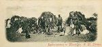
The city was also at one point referred to as Ankh-Tawy (meaning “Life of the Two Lands“), stressing the strategic position of the city between Upper and Lower Egypt. This name appears to date from the Middle Kingdom (c. 2055–1640 BCE), and is frequently found in ancient Egyptian texts.

At the beginning of the New Kingdom (c. 1550 BCE), the city became known as Men-nefer (meaning “enduring and beautiful“), which became Menfe in Coptic. The name “Memphis” is the Greek adaptation of this name, which was originally the name of the pyramid of Pepi I, located west of the city.

Memphis_Hout ka Ptah
Hut-ka-Ptah

The Egyptian historian Manetho referred to Memphis as Hut-ka-Ptah (meaning “Enclosure of the ka of Ptah“). In the Bible, Memphis is called Moph or Noph. 

Memphis_Great temple of Ptah
Depiction of the western forecourt to the Great Temple of Ptah in Memphis (Wikipedia)

According to legend related by Manetho, an Egyptian priest and historian from the 3rd century BC, the city of Memphis was founded by the pharaoh Menes. It was the capital of Egypt during the Old Kingdom, and remained an important city throughout ancient Mediterranean history. It occupied a strategic position at the mouth of the Nile delta, and was home to feverish activity. Its principal port, Peru-nefer, harbored a high density of workshops, factories, and warehouses that distributed food and merchandise throughout the ancient kingdom. During its golden age, Memphis thrived as a regional center for commerce, trade, and religion. Its eventual downfall is believed to be due to the loss of its economic significance in late antiquity, following the rise of coastal Alexandria. Its religious significance also diminished after the abandonment of the ancient religion following the Edict of Thessalonica.

Memphis_Alexandre visitant le temple de Memphis 1898
Alexander visiting the Temple of Apis in Memphis, ca 1898 (Wikipedia)

The ruins of the former capital today offer fragmented evidence of its glorious past. They have been preserved, along with the pyramid complex at Giza, as a World Heritage Site since 1979. The site is open to the public as an open-air museum.

Memphis became the capital of Ancient Egypt for over eight consecutive dynasties during the Old Kingdom. The city reached a peak of prestige under the 6th dynasty as a center for the worship of Ptah, the god of creation and artworks.

Memphis declined briefly after the 18th dynasty with the rise of Thebes and the New Kingdom, and was revived under the Persians before falling firmly into second place following the foundation of Alexandria. Under the Roman Empire, Alexandria remained the most important Egyptian city. Memphis remained the second city of Egypt until the establishment of Fustat in 641 CE. It was then largely abandoned and became a source of stone for the surrounding settlements. It was still an imposing set of ruins in the 12th century but soon became a little more than an expanse of low ruins and scattered stone.

So whenever you think of going to Memphis, Tennessee, or about the birthplace of Blues, remember Memphis, the capital of ancient Egypt, the heart of great pharaohs, and the “enduring, and beautiful” place which has now become an important part of world history and stored greatness throughout centuries. No wonder one of its names was “everlasting places”; it has actually been an everlasting place!

Why the name: Bamako?

Map of Mali with its capital Bamako

What does Bamako have in common with London, Paris, Amsterdam, Berlin, or Madrid? Of course it is the capital of a country, Mali, like all those other cities. However, the real similarity, is that it is located on the banks of a major river (like all those cities): the third largest river on the African continent, the Niger River, also known as Joliba (or the river of blood), near the rapids that divide the upper and middle Niger valleys in the southwestern part of the country. The city first grew on the north banks of the river, and later spread to the south banks as well.

Flag of Mali
Flag of Mali

The name Bamako comes from the Bambara word Bàmakɔ̌ meaning “river of crocodile“. It was founded at the end of the 16th century by the Niaré people, also called Niakaté, who are Sarakolés. The crocodile being the fetish of Bamako, in the olden days, a virgin girl was offered to it every year… however this tradition was abandoned a long time ago. A hunter from Lambidou (Kayes region) by the name of Simballa Niakaté chose the city’s site. However, it was his eldest son Diamoussa Niakaté who founded the city Bamako. The 3 crocodiles which symbolize Bamako found their origin in the 3 creeks that crossed Bamako: Lido, Diafarana, and Bèlèsôkô. The creeks come together in the city to flow into the Niger river. Just as the city’s symbol is 3 crocodiles, and so 3 creeks/rivers, it also comprises 3 major bridges which link both banks of the Niger River.

Mali Empire (Wikipedia)

The area of the city has been continuously inhabited since the Palaeolithic era for more than 150,000 years. The fertile lands of the Niger River Valley provided the people with an abundant food supply and early kingdoms in the area grew wealthy as they established trade routes linking across West Africa, the Sahara, and leading to northern Africa and Europe. The early inhabitants traded gold, ivory, kola nuts, and salt. By the 11th century, the Empire of Ghana (this will be the subject of a post soon) became the first kingdom to dominate the area. Bamako had become a major market town, and a pathway to Timbuktu the center of knowledge via the Niger river. Later, the Mali Empire grew during the early Middle Ages and replaced the Empire of Ghana as the dominant kingdom in West Africa, dominating Senegal, Gambia, Guinea, Mali, and Mauritania. In the 14th century, the Mali Empire became increasingly wealthy because of the trade of cotton and salt. It was eventually succeeded by the Songhai Empire.

The Pink Market (Le Marche Rose) in Bamako ca 1900s

By the late 19th century, the French dominated much of western Africa, and in 1883, present-day Mali became part of the colony of French Sudan, and was its capital in 1908. Cotton and rice farming was encouraged through large irrigation projects and a new railroad connected Bamako to Dakar on the Atlantic coast. Mali was annexed then into French West Africa, a federation which lasted from 1895 to 1959. Bamako remained the capital of Mali after independence in 1960.

Bamako on the banks of the Niger River (Wikipedia)
Bamako, on the banks of the Niger River (Wikipedia)

Bamako is known as the crossroads of West Africa, since it is located 1000 km from Dakar (Senegal) and Abidjan(Côte d’Ivoire), 850 km from Ouagadougou (Burkina Faso), and 120 km from the border with Guinea. With a population of 1.8 million, Bamako is viewed today as the fastest growing city in Africa and sixth-fastest in the world. It is a buoyant city full of life. Enjoy a visit to the “river of crocodiles,” the crossroad of West Africa, and don’t forget to bathe in the centuries’ old history of great West African kingdoms in Mali, and its rich traditions.

Proverbe Peul sur l’Expérience / Fula Proverb on Experience

African man (Said Abdallah by Cordier, 1848)

Un vieillard reste assis et voit; l’enfant se tient debout et ne voit rien (Proverbe Peul – Afrique de l’Ouest et une partie de l’Afrique centrale). – Expérience de la vie.

child3An old man sits down and sees; the child stands up and sees nothing (Fula proverb – West Africa and part of Central Africa). – Life experience.

Why the name: São Tomé and Príncipe?

Sao Tome Flag

I used to love the sound of it: São Tomé e Príncipe… and always wondered: why have two names for one country? why the joined names? why not just name it São Tomé? Just like Trinidad and Tobago, São Tomé and Príncipe is in fact two islands, and just like T&T, the largest one is the first one in the combo name: São Tomé. However, unlike Trinidad and Tobago whose capital is Port of Spain, São Tomé and Príncipe’s capital is named … you guessed it: São Tomé!

São Tomé and Príncipe
São Tomé and Príncipe map

The islands of São Tomé and Príncipe are situated in central Africa, in the equatorial Atlantic ocean and Gulf of Guinea about 300 and 250 kilometres, respectively, off the northwest coast of Gabon; it is Africa’s second smallest country after Seychelles. Both islands are part of the Cameroon volcanic mountain line, which also includes the islands of Annobón to the southwest, Bioko to the northeast (both part of Equatorial Guinea), and Mount Cameroon in Cameroon. Its tallest mountain is with Pico de São Tomé at 2,024 m.

São Tomé 1645
São Tomé 1645

So why the combo name and what does it mean? São Tomé was founded by Álvaro Caminha in 1493, who received the land as a grant from the Portuguese crown to grow sugar. The island was uninhabited before the arrival of the Portuguese sometime around 1470. (I always doubt these accounts which state an island as uninhabited; after all didn’t Christopher Columbus discover America even though it was already inhabited?).  Príncipe was settled in 1500 under a similar arrangement. São Tomé was right on the equator and wet enough to grow sugar in wild abundance. Its proximity to the African Kingdom of Kongo provided an eventual source of slave laborers to work the sugar plantations. The dates of discovery, by explorers João de Santarém and Pêro Escobar, are sometimes given as 21 December (St Thomas’s Day) 1471 for São Tomé, and 17 January (St Anthony’s Day) 1472 for Príncipe. Thus São Tomé stands for Saint Thomas. Príncipe was initially named Santo Antão (“Saint Anthony”), changing its name in 1502 to Ilha do Príncipe (“Prince’s Island”), in reference to the Prince of Portugal to whom duties on the island’s sugar crop were paid. Thus Principe stands for Prince. Hence São Tomé e Príncipe really stands for Saint Thomas and Prince.

Principe in 1727
Principe in 1727

Attracting European settlers to the islands proved difficult, and most of the earliest inhabitants were “undesirables” (like in so many colonies) sent from Portugal, mostly Jews. In time these settlers found the volcanic soil of the region suitable for agriculture, especially the growing of sugar, and brought slaves from the neighboring Kingdom of Kongo to work those plantations.

Sao Tome and Principe today

São Tomé is centered on a sixteenth-century cathedral. Another early building is Fort São Sebastião, built in 1575 and now the São Tomé National Museum. In 1599, the city as well as the islands were taken by the Dutch for two days and again in 1641 for a year. It was the capital of the Portuguese colony of São Tomé and Príncipe and, since São Tomé and Príncipe‘s independence on 12 July 1975, capital of the sovereign nation.

The country’s economy is centered around cash crops: sugar, cocoa, and coffee. Tourism is also another big economic driver for the country.