I always loved the sound of the name Ouagadougou as it rolled off my tongue: it felt like a mouthful, but like a happy mouthful, the one you say with love: OUA-GA-DOU-GOU (WA-GA-DU-GU). Remember this is the capital of the land of upright people, the land of this proud son of Africa, Thomas Sankara. Yes, you know, the capital of Burkina Faso.
Originally, the city was called Kombemtinga, or the “land of princes.” It was founded on the 11th century by the Nyonyonse people.
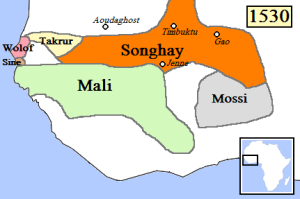
West Africa in 1530, with Mossi kingdom on the bottom right (Wikipedia)
The name Ouagadougoudates back to the 15th century when the Ninsi tribes inhabited the area. According to the Larlé Naba, the holder of the Mossi Empire‘s secrets, the city founders were in constant conflict with neighboring people until 1441, when they were forced to seek the protection of the Mossi Emperor Zoungrana, who was then living in Tenkodogo. In 1441, Wubri, Zoungrana‘s son, and an important figure in Burkina Faso‘s history, led his tribe to victory. He then renamed the area from “Kombemtinga” or “Kumbee-Tenga“, as the Ninsi had called it, to “Wogdgo” which meant “Come honor me“.
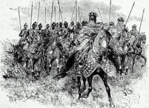
Mossi cavalry, ca 1800s
It is this appellation which has evolved to “Woghodogo,” then Ouagadougoufrom the French. Others say that the name was changed by Wubri from “Kombemtinga” to “Wage sabre soba koumbem tenga“, meaning “head war chief’s village“. The city then became the capital of the Mossi Empire in 1441 and the permanent residence of the Mossi emperors (Moro-Naba, Mogho Naaba) starting in 1681 with Naba Sanem. The Moro-Naba Ceremony is still performed every Friday by the Moro-Naba and his court to this day. The French made Ouagadougou the capital of the Upper Volta territory (basically the same area as contemporary independent Burkina Faso) in 1919.
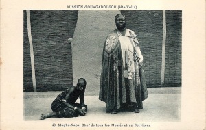
The Mogho Naba, king of the Mossi people at court in Ouagadougou, ca 1910 (Source: AdireAfricanTextiles.blogspot.com)
The name was originally « Woogrtenga » and « Wogodogo » to mean « where we receive honors, respect». Ouagadougou grew around the imperial palace of the Mogho Naaba. Being an administrative center of colonial rule, it became an important urban center in the post-colonial era. First the capital of the Mossi Kingdoms and later of Upper Volta and then Burkina Faso, Ouagadougoubecame a veritable communal center in 1995. Affectionately called Ouagaby most, it is the center of the African film festival, FESPACO.
Ouaga2000 Memorial – Ouagadougou today
So if you visit Ouagadougou, remember that you are visiting the original land of the princes, and the place where we receive honors and respect. Isn’t it a name worthy of the capital of the land of the upright people(Burkina Faso)? Enjoy the video below about Ouagadougou.
As you travel around Africa, have you ever wondered about the name of the second largest city of Angola, Huambo ?
Previously called Nova Lisboa (New Lisbon) after the capital of Portugal, Huambogot its name from Wambu, one of the 14 old Ovimbundu kingdoms of the central Angolan plateau. The Ovimbundu, an old tribe of Angola, which originally arrived from Eastern Africa, had founded their central kingdom of Bailundu as early as the 15th century. Wambuwas one of the smaller kingdoms and was hierarchically under the King of Bailundu, though it enjoyed, as the other kingdoms, a considerable degree of independence.
The House of the Governor in Huambo (Source: Wikipedia)
Situated in the Angolan central highlands, Huambois located near the headwaters of the Kunene River. It was founded in 1912 by Portuguese colons and was called Nova Lisboa until 1975, when it resumed its name of Huambo. It is located 600 km southeast of the capital Luanda, and 220 km east of Benguela; it is at high altitude, on a plateau 1800 m above sea level. Huambo is a main hub on the Caminho de Ferro de Benguela (CFB) (the Benguela Railway), which runs from the port of Lobito in Angola, to the Democratic Republic of the Congo‘s southernmost province, Katanga. It is the second industrial city of the country, and a big agricultural center.
If you ever visit Huambo, as you tour its neighborhoods, and get on the Caminho de Ferro de Benguela, remember that it was once an old Ovimbundu kingdom, Wambu, and reconnect with the feel of this ancient kingdom!
Have you ever wondered about the meaning of Mbabane, the name of the capital of Swaziland? Have you ever wondered what the local people called their land, before the arrival of European settlers? Well, I have. It sounds so off, to be called Swaziland, or the land of the Swazi people. Very often in world history, it seems as if a place or people gets its name from foreigners, rather than the indigenous people, i.e how could a place be called Léopoldville (Kinshasa), when the locals do not call it? How could a place be called Cote d’Ivoire? Was there not a local name for that area? After digressing a bit, I wondered about the name Swaziland, or the land of the Swazi people. How do the Swazi know themselves? Or how do they call their land? How do they call their capital?
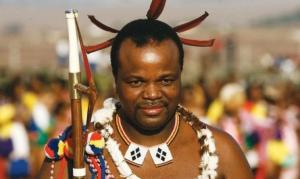
King Mswati III of Swaziland (Source: News24.com)
The city of Mbabanegets its name from a local king, Mbabane Kunene, who lived in the region when the British colonizers first arrived there. It is the capital of Swaziland, and the country’s largest city. It is located on the Mbabane River and its tributary the Polinjane River in the Mdzimba Mountains. It is located in the Hhohho Region, of which it is also the capital. The average elevation of the city is 1243 meters. Swaziland is a monarchy headed by King Mswati III, who was crowned King on 25 April 1986 and Ingwenyama of Swaziland. He reigns with his mother, Queen Mother Ntfombi Tfwala, the Ndlovukati and Joint Head of State of Swaziland since 1986. The country, Swaziland, gets its name from King Mswati II who helped expand and unify the area in the 19th-century. Today, most people belong to the Swazi tribe, and the country is also known as kaNgwane, after King Ngwane III.
Whenever you find your way in Swaziland, do not forget to visit Mbabane, King Mswati III’s capital, and enjoy Swazi culture.
How many people know the country of Comoros? Have you ever heard about it? Have you ever wondered where the name Comoros come from? Well, I have… At first I wondered if it was like Cameroon, whose name comes from Rio dosCamarões, and so since Comoros seems to rime with Camarões, will Comoros mean Shrimp?
Well, my previous assumption was forgetting the fact that the Comoros, or rather the Union of the Comoros, had once seen the influence of Arabic sailors. So, the name Comoroscomes from the Arabic word qamar, meaning moon! He he he… Comorosessentially means Moon.
The Comoros with the map of Africa (Countryreports.org)
Comoros is a nation formed at the crossroads of different civilizations; it is almost like Madagascar in its cultural diversity: it was first inhabited by Bantu speakers from East Africa, and later its population was supplemented by Arab and Austronesian immigration. Islam was introduced around after the 650s AD. It was a major hub of trade and an important location in a network of trading towns that included Kilwa, in present-day Tanzania, Sofala (an outlet for Zimbabwean gold), in Mozambique, and Mombasa in Kenya. The country became part of the French colonial empire in the 19th century before becoming independent in 1975.
Port of Moroni, Comoros (1908)
The Comoros is formed by Ngazidja (Grande Comore), Mwali (Mohéli) and Nzwani (Anjouan), three major islands in the Comoros Archipelago, as well as many minor islets. The capital and largest city, Moroni, is located on Ngazidja. The archipelago is situated in the Indian Ocean, in the Mozambique Channel, between the African coast (nearest to Mozambique and Tanzania) and Madagascar, with no land borders. In addition, the country has a claim on a fourth major island, southeastern-most Mayotte (Maore), though Mayotte voted against independence from France in 1974, has never been administered by an independent Comoros government, and continues to be administered by France (currently as an overseas department). France has vetoedUnited Nations Security Councilresolutions that would affirm Comorian sovereignty over the island.
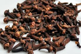
Cloves
The main export of the islands are vanilla, ylang-ylang, and clove. The Comoros are the world’s largest producer of ylang-ylang.
So, if you ever visit the Comoros, imagine the moon! Enjoy its sandy beaches, and its lovely people!
What comes to mind as you say the name of the capital of Sudan, Khartoum? Well, for me, I imagine the great Nubian Empire with its queen Amanishakheto or King Taharqa; I imagine big sand dunes, and of course history… so much history, the history of one of the greatest African kingdoms, one which dominated ancient Egypt for centuries. So how far am I from the real meaning of the name Khartoum?
The origin of the word, “Khartoum“, is uncertain. There are many interpretations. One of them states that the name khartoumis derived from the Arabickhurṭūm(tusks, trunkor hose) for elephant tusks, or it could be referring to the narrow strip of land extending between the Blue and White Niles [not sure how trunk or hose could be thought to be a strip of land].
Pyramids of Nubia (Wikipedia)
Captain J.A. Grant, who reached Khartoum in 1863 with Captain Speke‘s expedition, thought the name was most probably from the Arabic qurtum(قرطمsafflower, i.e., Carthamus tinctorius), which was cultivated extensively in Egypt for its oil to be used as fuel [not sure why a city in Sudan will be named for a plant which is cultivated in its neighbor’s country]. Some scholars speculate that the word may be derived from the Nubian word, Agartum (“the abode of Atum“), the Nubian and Egyptian god of creation. Other Beja scholars suggest “Khartoum” is derived from the Beja word, Hartoom(“meeting“). Additionally, the dream interpreting magicians in Genesis 41:8 are referred to as חַרְטֻמֵּ֥י (Khartoumei) [as you can see Black Africans are in the Bible everywhere].
So, which one of these interpretations is the most accurate?
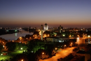
Khartoum, today (Source:Wikipedia)
The city as it is known today was established in 1821, 24 kilometers north of the ancient city of Soba, by Ibrahim Pasha, the son of Egypt‘s ruler, Muhammad Ali Pasha, who had just incorporated Sudan into his realm. Originally, Khartoum served as an outpost for the Egyptian Army, but the settlement quickly grew into a regional center of trade. It also became a focal point for the slave trade. Later, it became the administrative center of Sudan and official capital.
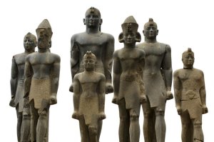
Black Pharaohs of Nubia
Khartoum is located in the middle of the populated areas in Sudan, and is part of the tri-cities composed of Khartoum proper, and linked by bridges to Khartoum North and Omdurman to the west, with an overall population of 5 million inhabitants. Khartoum and Sudan as whole, were the home of several ancient flourishing civilizations, such as Nubia, the Kingdom of Kush, Kerma, Nobatia, Alodia, Makuria, Meroë and others, most of which flourished along the Nile. During the pre-dynastic period Nubia and Nagadan Upper Egypt were identical, simultaneously evolved systems of Pharaonic kingship by 3300 BC. Khartoum is home to amazing museums, including the largest museum of Sudan, the National Museum of Sudan, where one can be immersed in the rich culture of Sudan and the different eras of its history. Among the exhibits are two Egyptian temples of Buhen and Semna, originally built by Queen Hatshepsut and Pharaoh Tuthmosis III, respectively, but relocated to Khartoum upon the flooding of Lake Nasser.
Well, if you visit Khartoum, don’t forget to visit the National Museum of Sudan, and learn of the great African civilizations that flourish there, reclaim your history, African history, and above all enjoy the warmth and hospitality of the people of Khartoum!
What comes to mind when you say the name of the capital of Mauritania, Nouakchott? Well, to me, instant thoughts of sandy dunes, the Atlantic ocean, and the desert come to mind. So does its name come close to any of these?
Nouakchottor Nuwākshūṭin Arabic, is originally derived from the BerberNawākšūṭ, or “place of the winds,” and is the capital and largest city of Mauritania, as well as being one of the largest cities in the Sahara. From the different transcriptions, the name of the city, Nouakchottor Noiakchott gave rise to different translations, among which 5 principal ones:
Flag of Mauritania
“place where water appears when a well is dug“
“land where shells abound“
“place with salted pasture“
“place where the wind blows“
“without ears“
Chottmay mean beach or foreshore or batture. Nouain hassaniya Arabic (Moor dialect) means “bay.” Thus, Nouakchottliterally means “the beach of the bay.” Even though the Mauritanian shoreline does not present any bays on the outskirts of Nouakchott, the shape of the coastline is slightly hollow there.
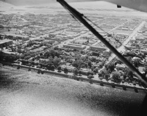
Aerial view of Nouakchott 2002 (Wikipedia)
Nouakchott was a small fortified fishing village (ksar) in pre-colonial times and during French rule. Early in colonial times, the city was a French military camp where Mauritanians were not allowed to stay. In 1958, it was chosen by Moktar Ould Daddah, the country’s first president, as the capital of the nascent nation of Mauritania. The village was selected as the capital city for its central location between Saint-Louis, Senegal, the city from which the colony of Mauritania was governed, and Nouadhibou, Mauritania’s second largest city.
Fishermen in Nouakchott (Wikipedia)
Nouakchott is located on the Atlantic coast of the Sahara Desert. It is largely flat, and only a few meters above sea level. It is daily exposed to sand dunes. Nouakchott is built around a large tree-lined street, Avenue Gamal Abdel Nasser, which runs northeast through the city centre from the airport. It divides the city into two, with the residential areas in the north and the medina quarter, and shantytowns to the south. The main neighborhoods are Arafat, Dar Naim, El Mina, Ksar, Riyadh, Sebkha, Tevragh-Zeina, and Toujounine.
Camel market in Nouakchott (Wikipedia)
Today, the city is the heart of the Mauritanian economy and is home to a deepwater port and one of the country’s two international airports. It also hosts the University of Nouakchott. If you visit Nouakchott, don’t forget to visit the camel market, a very big attraction in a country where a lot of its population is nomadic.
Have you ever wondered what the name of the second largest city of the Democratic Republic of the Congo (DRC), Lubumbashi, meant? Well, growing up, I always loved the sound of it as it rolled off the tongue: LU–BUM–BA–SHI: so full of power… so full of ummph, like thunder! So do you think the name has anything to do with power? or thunder?
Express to Rhodesia from Elisabethville’s train station (trains-worldexpresses.com)
The area as it is known today has been inhabited for centuries, but the modern-day city itself was ‘founded’ by the Belgians in 1910 under the name of Élisabethville(sometimes Elizabethville, both in French, or Elisabethstad in Dutch), in honor of their queen Elisabeth, wife to king Albert I. It was affectionately referred to as É-Ville. It was the second city of the Belgian Congo, after Léopoldville. Élisabethville functioned as the administrative capital of the Katanga Province. It was also an important mining, commercial and industrial center, and a center of education and health services. The work and businesses related to the mines made Élisabethville the most prosperous region of the Congo during the final decade of Belgian rule. Today it is the mining capital of the entire country, with its production in copper, cobalt, zinc, gold, Tin, etc.
Malachite specimen from Katanga, on display at the Royal Ontario Museum (Wikipedia)
In 1965, Mobutu Sese Seko with his campaign to identify himself with African nationalism or “Zairianization” politics assumed power of Congo, which he renamed Zaïre. In this push, he renamed Élisabethville as “Lubumbashi” in 1966 and, in 1972 renamed the Katanga Province as “Shaba.” It was named Lubumbashi after the local river by the same name Lubumbashi. It is also called the copper capital. Copper mining in Katanga dates back over 1,000 years and mines in the region were producing standard sized ingots of copper for international transport by the end of the 1st Millennium AD.
Aerial view of Lubumbashi (Source: Aerocam Congo)
As was customary in sub-Saharan colonies, the city center of Élisabethville was reserved for the white (European-Only Neighborhoods in African Cities before Independence) population. This consisted mainly of Belgian nationals, but also British, Italian, and Jewish Greek communities. The black population lived initially in a so-called cité indigène called quartierAlbert (now: Kamalondo), south of the city center and separated from the white city by a 700-metres-wide neutral zone. With population growth, new indigenous neighborhoods were created. These still form the main suburbs of present-day Lubumbashi: Kenia, Katuba, Ruashi. In addition to these 3, 4 more communes have been added to this day: Kamalondo, Kampemba, Lubumbashi, and la Commune Annexe.
Fountain at the Place Moise Tshombe in Lubumbashi (Source: Congo-Autrement)
Today, the city of Lubumbashi is affectionately called by locals, L’shi or Lubum, and its inhabitants are known as the Lushois. French is the official language, but the main language spoken by most is Kiswahili. Lubumbashi lies at high altitude at about 1,208 meters (3,963 ft) above sea level, which gives rise to a cooler climate. It is a cosmopolitan city, with people from all over Congo, neighboring countries, and Europeans, Chinese, Americans, etc who mostly come for the mining industry; this has given rise to a gastronomical melting pot as well. The city is also host to one of Africa’s greatest soccer club: The TP Mazembe (Tout Puissant Mazembe). The club’s chairman is former Katanga governor Moïse Katumbi Chapwe. It is a vibrant city. To learn more about Lubumbashi, the cosmopolitan city named after its local river, check out the articles Lubumbashi urban mosaic, Presentation of Lubumbashi. Enjoy the video below on Lubumbashi, the mining capital of DRC!
Many cities around the globe have had their names changed during colonization times (by Europeans colonizers) and were made to carry names foreign to the local people, as denoted in Bombay (Mumbai), Léopoldville (Kinshasa), and Canton (Guangdong) to name just a few. Ever since independence, many of these cities and countries have been renamed to reflect the local culture. Harare is one such city. Harare, the capital of Zimbabwe (which used to be Rhodesia during colonial times), used to be named Salisbury.
So what’s in a name? Well, a name is everything, and characterizes who you are, and your connection to the place. So why shouldn’t Bombay remain Bombay…. Why the need to change it back to Mumbai after over a century as Bombay? Well simply because Mumbai or Guangdong is the way the local people call it, and these cities and their names should be seen through their eyes and not those of a foreigner who oftentimes loathes the local people, and sees them as inferior.
Harare’s skyline today (Wikipedia)
Back to Harare… During the time that the British with the infamous Barbarian Cecil Rhodes ‘colonized’ the place, it was known as Fort Salisbury. The city was founded in 1890 by the Pioneer Column, a small military force in the service of the British South Africa Company, and named Fort Salisbury after the British Prime Minister Lord Salisbury. It retained the name Salisbury until 1982, when it was renamed Harare on the second anniversary of Zimbabwean independence.
So Harare, the most populous, and capital city of Zimbabwe owes its present-day name to a local Shona chief by the name of Ne-Harawa, whose name meant “He who does notsleep.” The name of the city was changed to Harareon 18 April 1982, taking its name from the village near Harare Kopje of the Shona chief Ne-Harawa. Prior to independence, “Harare” was the name of the black residential area (indigenous area where the Black locals where allowed to live) now known as Mbare. It used to also be known as the Sunshine City.
A Conical tower at Great Zimbabwe
Situated at an elevation of 1,483 metres (4,865 feet) above sea level, Harare’s climate falls into the subtropical highland category. Administratively, Harare is a metropolitanprovince. It is Zimbabwe’s leading financial, commercial, and communications centre, and a trade centre for tobacco, maize, cotton, and citrus fruits. Manufactured goods include textiles, steel and chemicals, and gold is mined in the area.
National Heroes Acre (ZimbabweTourism.org)
My Dad visited Harare in the early 90s and loved every part of it. So if you ever visit Harare, remember that its name is for “He who does not sleep”, and enjoy its streets full of Msasa trees which color neighborhoods wine red in late August, and other streets filled with Jacaranda and Flamboyant trees. If you love colonial architecture, you will have your fill. If you are in search of African arts, visit the National Gallery (a side note, if you ever visit the Atlanta airport, one of the transition corridors is filled with Zimbabwean Shona sculptures); for flora lovers, the botanic garden is full of species only found there. The Mukuvisi Woodlands reserve is not too far, and you can visit the Shona village of Chapungu Kraal, as well as check out the Epworth rocks, the National Archives, and the Heroes Cemetery.
Yesterday, just as I published my article “Why the name: Zanzibar?” the BBC published a photo-journal on “ Saving Zanzibar’s Heritage.” This made for a happy surprise, and showed the effort taken by locals to save and restore Stone Town (Mji Mkongwe in Swahili)’s architecture. So please check out the article on BBC HERE. Enjoy!
Sultan Palace in Old Stone Town in Zanzibar (1871 – 1875)

 On ne conduit pas chez le coiffeur un enfant qui n’est pas encore né (Proverbe Dogon – Mali). – Ne vendez pas la peau de l’ours avant de l’avoir tué.


 So
So 


