Ethiopian Emperor Fasilides is one of most remarkable rulers of Abyssinia, the ancient name of Ethiopia. A member of the Solomonic dynasty, emperor Fasilides ruled over Abyssinia from 1632 to 1667. He founded the city of Gondar in 1636 which became the capital of Abyssinia, in the northwestern part of Ethiopia. He was known as Alam Sagad or ‘To whom the world bows.’ Today, thousands bow to his work, and his footprints have marked the history of Ethiopia forever.
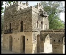
Fasilides’ Castle
Among the buildings he constructed there are the beginnings of the complex later known as Fasil Ghebbi, as well as some of the earliest of Gondar’s famous 44 churches: AdababayIyasus, Adababay Tekle Haymanot, Atatami Mikael, Gimjabet Maryam, Fit Mikael, and Fit Abbo. Fasilides is also credited with building seven stone bridges in Ethiopia. Sebara Dildiy (broken bridge in Amharic) was one of two stone bridges built over the Blue Nile River during Fasilides reign. Sebara Dildiy was later repaired during Emperor Menelik II‘s reign in 1901. Emperor Fasilides also built the Cathedral Church of St Mary of Zion at Axum. Fasilides’ church is known today as the “Old Cathedral” and stands next to a newer cathedral built by Emperor Haile Selassie.
Fasilides’ Bath
When King Fasilides made Gondar the seat of his empire in 1636, he constructed a palace that would eventually sprawl into a large complex, as succeessors added their own buildings to the compound. Set in the heart of what is now one of Ethiopia’s largest cities, the palace complex is a mixture of beautifully-preserved period architecture with European and Moorish influences, and rambling ruins. Interestingly, Fasilides’ Castle itself is the best-preserved, with its lower halls, reservoirs and steam-baths, remains of kitchens and stables, and even enclosures for leopards and lions that used to grace the grounds. The castle is located near the city center. Its structure is purely made of stone. Today, Fasilides baths are used for baptism during the Timkat festival, the epiphany, in late January; they are only filled with water for the festival. The castle can be found in Gondar, Amhara region. Fasilides’ Castle is definitely a representation of Ethiopia’s great and rich history.
Mirambo, the Black Napoleon (Source: Les Africain, C.-A. Julien, Ed. J.A., Vol, 6, P. 137 (1977))Mirambo’s empire, Urambo (source: Les Africains, C.-A. Julien, Ed. J.A., Vol.6, P. 135 (1977))
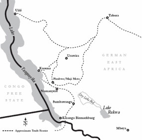
Following up on the article on Mirambo, the Black Napoleon or the Black Bonaparte, I propose here a map of his zone of influence after conquest of different regions. I found a map of Mirambo‘s kingdom, the Nyamwezi empire, Urambo, in ‘Les Africains, C.-A. Julien, Editions J.A., Vol. 6, P. 135 (1977).’ You will find his capitals: Iseramagazi and Ikonongo, Tabora, Ujiji, Lake Victoria and Lake Tanganyika the northern and western borders respectively. Enjoy!
Today, I will talk about Mirambo, the man the explorer Henry Morton Stanley first referred to as a bandit, and later on as the Napoleon of Africa for his military prowess. Who was Mirambo?
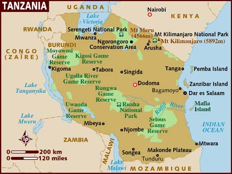
Map of Tanzania
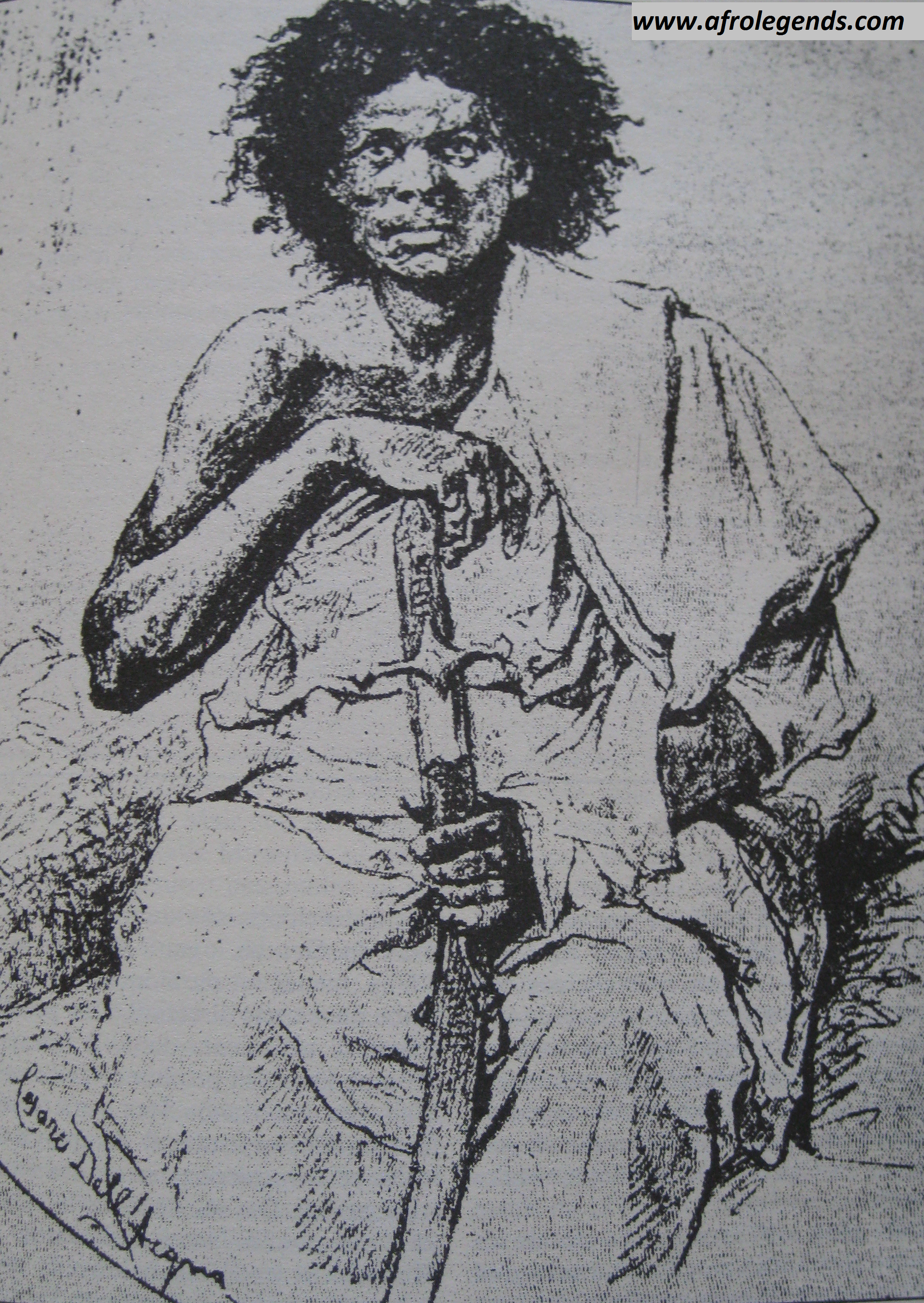
Born Mbula Mtelya, Mirambo is the man who revolutionized nineteenth century Tanzania, and made it hard for the Germans to conquer the region: he united the numerous Nyamwezi tribes, and gained control over Swahili-Arab trade routes. Mirambo was the leader of the Nyamwezi people on a 200,000 km2 territory south of Lake Nyanza (Lake Victoria), and east of Lake Tanganyika. He was not a vulgar chief of brigands as the Arab traders made Stanley believe in 1871, but his links to different families of Ntemi(kings) were a little bit blurred as many historians had mixed up dynastic and genealogical lineages, different in a matrilineal system such as that of the Nyamwezis. In 1858, Mirambo managed to inherit the chiefdom of Uyowa from his father, Kasanda, who was a renowned warrior; he was only 18 years old. In 1860, he joined two chiefdoms located 100 km west of Tabora, in the kingdom of Unyanyembe. He learned the Ngoni language (Ngoni people trace their origin to the Zulu people of KwaZulu Natal), as well as their military techniques. Later in 1860, he conquered the neighboring territory of Ulyankuru.
Map of Mirambo’s kingdom
He then moved his capital to Iseramagazi where he built a Boma, a fortified residence, with walls made up of dry bricks, retrenchments and hedges of euphorbia flowers. From his father and mother, he was a descendent of Mshimba (lion), the last ruler of the legendary kingdom of Usagali, and Mirambo was thus recreating the old empire. Thus in 1860, he created a new Nyamwezi state, the Urambo, from the name he had adopted for himself, ‘corpses‘ in kinyamwezi, Mirambo. From 1860 to 1870, he strengthened his authority along the banks of the river Gombe, i.e. on the road to Ujiji, thereby threatening to block the Arab commerce in the area. In 1871, he defeated the Arab traders at Tabora. The Sultan of Zanzibar, Barghash bin Said, retaliated by sending 3000 soldiers (2000 Swahili, and 1000 Balutchi). Mirambo’s resistance was one of the most fierce: Nyamwezi’s fighters would go as far as melting their copper bracelets to make bullets for their guns. A compromise was made to keep commerce flowing with the coast: caravans could pass after paying a tax (hongo) to Mirambo.
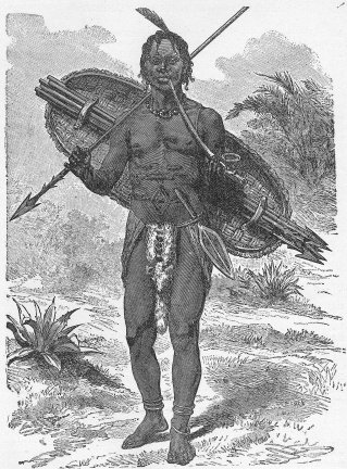
Illustration of the Ntemi of Urambo, Mirambo (from James William Buels Heroes of the Dark Continent (1890))
Every year, during the dry season, Mirambo would dispatch his ruga-ruga in all directions to continue the expansion of his territory. From 1876 to 1878, the territory was expanded to the north, up to the southern banks of Lake Victoria. From 1879 to 1881, expansion to the west toward Uvinza, for the control of Lake Tanganyika. The Muhambwe of King Ruhaga fell under Nyamwezi domination, and the Ruguru of King Ntare had to seek protection from Mirambo and agree to the presence of a ruga-ruga post on the eastern border of his kingdom. In 1879, there was also the expansion towards Burundi. His alliance with the Ngoni fell apart in the early 1880s. He was greatly hated by the Arabs who used to dominate the commerce in the region, and other neighboring kings who feared him, and the Europeans who saw in him as a powerful adversary. After 1881, the Arabs managed to convince the International African Association (AIA – Association Internationale Africaine), a European power created under King Leopold II’s initiative to inflict an embargo on arms and munitions on Mirambo (yup… European unions already inflicted embargo on arms back then). The goal of the AIA was to “open up central Africa to civilization.” At first Mirambo’s army succeeded in entering Burundi by surprise using a feud between the local king and his brother, but in 1884, his army was defeated by Burundi warriors (aided by Ngoni warriors). After his defeat in Burundi, and another defeat against the alliance of the Arabs and the Ntemiof Bukune, Mirambo’s troops were led by Mpandashalo as he was increasingly sick. Mirambo died on 2 December 1884.
Flag of Tanzania
Mirambo was a strong and ambitious leader. He expanded his authority and influence over a number of Nyamwezi chiefs. One of his challenges was to devise a political system that would allow him to consolidate his power, while ever expanding his territory. For that, he made sure not to change the structure of the Nyamwezi’s society: once in power, he would usually choose a successor from the same family. As long as the new chiefs pledged allegiance to him, they would be left to go about their political duties. The conquered chiefs had to provide troops at all times. His greatest strength was military. He used surprise as a tactical ploy. His capital was both a military and economic center. He had two residences: Iseramagazi from 1879, and Ikonongo from 1881.
Mirambo was actually a simple man, deeply rooted in his culture and traditions, but also very curious of the world. He was a man of order and progress, who will set the price of commodities in the capital’s markets, and regulated the consumption of alcohol in his kingdoms (he thought that alcohol weakened societies – just like Gungunyane), and meditated on the decadence of Africa in the 19th century. He was nostalgic of the magnificent ancient African capitals, and kingdoms. In essence, Mirambo had 4 faces: the traditional king, the warrior leader, the state builder, and the modernizer. To learn more, go to: ThinkAfricaPress.com, BlackPast.org, and Les Africains, Vol. 6, editions J.A, C.-A. Julien, P. 127-157, (1977).
Young girl attending the Timkat Festival (Carlos de Souza, AFP)Timkat festival
Today, I would like to talk about the Timkat Festival, which is an Ethiopian celebration of Epiphany. It is usually celebrated on 19 January or on 20 January on leap years (which is the 10th day of the Terr – Ethiopian calendar). This festival celebrates the baptism of Jesus Christ on the Jordan river by John the Baptist. It is particularly praised for its reenactment of the baptism. Pilgrims come from around the country to celebrate the Epiphany, which lasts three (3) days. During the ceremonies of Timkat, the Tabot, a model of the Ark of the Covenant, is reverently wrapped in rich cloth and borne in procession on the head of the most senior priest to a place near the river, where a special tent will be erected for it. The Tabot represents the manifestation of Jesus as the Messiah when he came to the Jordan river for baptism; this holy relic is also said to hold the ten commandments as handed down to Moses by God on Mount Sinai. The Divine Liturgy is celebrated near a stream or pool early in the morning (around 2 a.m.). Then the nearby body of water is blessed towards dawn and sprinkled on the participants, some of whom enter the water and immerse themselves, symbolically renewing their baptismal vows. It is a feast of celebration, and processional crosses of varying size and elaboration as well as various Ethiopian artifacts can be seen on the occasion. Participants wear the traditional shamma, which is a thin, white cotton wrap worn like a toga and as headdress. The best place to attend the event is in Lalibela, Gondar, or Addis Ababa. The actual ark of the Covenant is said to be held in a place in northern Ethiopia, guarded by priests who have sworn never to leave the chapel grounds.
Today, I will tell you about the Battle of Isandlwana, the battle where the mighty Great Britain lost to African warriors… Yes you heard me right: Great Britain lost to Zulu warriors in South Africa on 22 January 1879. The battle of Isandlwana remains the single greatest defeat of the British army at the hands of a native army. This occurred in KwaZulu-Natal, where approximately 22,000Zulu warriors defeated a contingent of approximately 1,350 British and Native troops (notice… the real number for the native forces cannot be found anywhere) in one of the first engagements of the Anglo-Zulu war. The Zulu force was under King Cetshwayo, a nephew of King Shaka Zulu.
Zulu King Cetshwayo, ca 1879
The Battle of Isandlwana is a battle of pride as it reminds us that our ancestors did not quietly accept colonization, and were not easily defeated. They fought, and even defeated the European colonizers, as is the case for Cetshwayo’s forces. The battle was a decisive victory for the Zulus and caused the defeat of the first British invasion of Zululand. For the first time, the British Army suffered its worst defeat against a technologically inferior indigenous force. Isandlwana resulted in the British taking a much more aggressive approach in the Anglo–Zulu War, leading to a heavily reinforced second invasion and the destruction of King Cetshwayo’s hopes of a negotiated peace.
A depiction of the Battle of Isandlwana, taken from the London News
The Zulus were equipped mainly with the traditional assegai (iklwa) iron spears and cow-hide shields. The British and colonial troops were armed with the state-of-the-art Martini-Henry breech-loading rifle and two 7 pounder artillery pieces as well as a rocket battery. He he he… Despite a vast disadvantage in weapons technology, the numerically superior Zulus commanded by inDunas(Princes) Ntshingwayo kaMahole Khoza and Mavumengwana kaNdlela Ntuli ultimately overwhelmed the British, killing over 1,300 troops, including all those out on the forward firing line. The Zulu army wiped six (6) companies of the 24th regiment as well as volunteers from the Natal province and Basotho auxiliaries under Colonel Durnford. The Zulu army suffered around a thousand killed.
Zulu warriors at Isandlwana, 1879
The primary reason for the Zulu victory is that the Zulus, unlike the British, kept their main fighting force concentrated. Further, they made a very successful effort to conceal the advance and location of their force until they were within a few hours’ striking distance of their enemy. See… my ancestors were military geniuses too!! Created by King Shaka, the Zulu army or Zulu impi was the most powerful war machine the British ever faced in Southern Africa. The combat strategy was perfected by King Shaka himself, who added great organization and discipline to the traditional qualities of courage and mobility cultivated within African armies. During the battle, the Zulu army would organize itself as an arc facing the adversary. At the center (known as the chest in Zulu) were found the most seasoned regiments; on the wings (or horns) were found the regiments of younger warriors. The latter used their speed and agility to outflank the enemy by attacking him on the flanks while trying to encircle him, while the chest warriors engaged him in the front. Behind the chest, and with their back turned so as to keep their calm, were the veteran regiments (also known as the kidneys) who will wait as reserves, intervening only to switch the battle to victory. Every man knew his place, moves, and maneuvers with extreme precision.
A Zulu regiment attacking at Isandlwana (C. Fripp)
Finally, when the location of the main Zulu Impi was discovered by British scouts, the Zulus, without hesitation, immediately advanced and attacked, achieving tactical surprise. This tactical surprise prevented the British, although they now had some warning of a Zulu advance, from concentrating their central column. The Zulus had outmanoeuvred Chelmsford, and their victory at Isandlwana was a decisive defeat of the British invasion that forced the main British force to retreat out of Zululand until a far larger British army could be shipped to South Africa for a second invasion. During this battle, there was also a solar eclipse; this however did not stop the warriors from fighting.
I have to admit that I was quite proud to learn about the battle of Isandlwana, the battle the British lost to technologically inferior Zulus warriors (so it is said). I just think that, on that day, the Zulus despite not having the technological advantage, had the strategic advantage. They were well-trained, well-prepared, and they were also fighting for their land. To learn more about the Battle of Isandlwana, please check out Military history which debunked some of the myths about the battle, British Battles, and this article on the BBC.
Queen Amina of Zazzau was born around 1533 in the province of Zazzau, in modern-day Nigeria. Zazzau refers to the Zaria emirate which is a traditional state with headquarters in the city of Zaria in Kaduna state in Nigeria. Zazzau was one of the seven Hausa city-states which dominated the subsaharan trade after the collapse of the Songhai Empire at the end of the 16th century. Its wealth was due to the commerce of leather, textile, horses, salt, kola, cloth, and metals imported from the East.
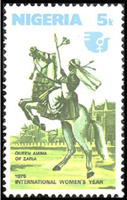
Queen Amina celebrated on a Nigerian stamp
As a toddler, Amina was already attending state business on her grandfather, the king’s laps. At the age of 16, Amina was seen as a potential contender to her mother’s throne (Magajiya), the queen Bakwa of Turunku. Amina started to learn the responsibilities of a queen from her mother: taking part in daily assemblies with high dignitaries of the kingdom. Even though her mother’s reign had been one of peace and prosperity, Amina chose to learn military skills from the warriors.
Queen Bakwa died around 1566, and the Zazzau kingdom was governed by her youngest brother Karama. During the reign of her brother, Amina emerged as principal warrior of the kingdom’s cavalry. Her military successes brought her wealth and power. When her brother died after ten years of reign, Amina was crowned queen of Zazzau in 1576. During her reign, which lasted 34 years, she expanded her kingdom’s boundaries down to the Atlantic coast, she founded several cities, and personally led an army of 20,000 soldiers to numerous battles. However, her focus was not on annexation of neighboring lands, but on forcing local rulers to accept vassal status and allow Hausa traders safe passage.
Portrait of Queen Amina
During her reign, she commanded the construction of a defensive mural around each military camp that she established. Later, those camps evolved into prosperous cities within those walls, and some can still be seen today in northern Nigeria. Those cities are known as walls ‘ganuwar of Amina’ or ‘Amina’s walls‘. It is believed that Amina died in the town of Altagara in 1610. Today, Amina is remembered in Nigeria as ‘Amina, rana de Yar Bakwa ta San’ (Amina, daughter of Nikatau, woman as capable as a man). The introduction of kola nuts into the region is often attributed to Amina. Amina is celebrated across the Hausaland as a great warrior queen who was born to rule, and led thousands of soldiers to war. To learn more, check out Black history heroes, History and Women, as well as the book African Princess which dedicates a chapter to this great queen. Amina’s achievement was the closest that any ruler had come in bringing the region now known as Nigeria under a single authority. Enjoy the video below of great African queens including Amina.
Yaoundé, the capital of Cameroon and its second largest city after Douala, is often known as “the city with the seven hills” because of the hills surrounding it… but what does it really mean? Does its name refer to its hills?
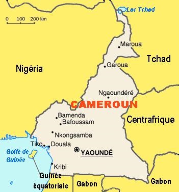
Map of Cameroon, with the capital Yaoundé
In Béti, Yaoundé is often called, Ongolo-Ewondo, or the Ewondos’ enclosure (la clôture des Ewondos). The city was born around 1889, when the German traders implanted a camp in the Ewondo region and called it Sono station after a local Ewondo chief Essono Ela who had offered them hospitality (the Germans had encountered a strong resistance in the Vouté and Eton regions). Hearing locals from the coast refer to it as Ya-Ewondo or Among the Ewondo (chez les Ewondos), the Germans called it ‘Jaunde’ and it later turned into ‘Yaunde’, and in French Yaoundé. The station later turned into an administrative region under the leadership of the botanist Zenker who established a detailed map of the area in 1890. Upon its creation, it was first a scientific post (probably because of the botanist), and later in 1895 became a military and trading post for ivory and rubber.
Yaoundé at night
Yaoundé was not always the country’s capital. After the 1909 volcanic eruption of Mt Cameroon in Buéa (Gbéa) which was then the capital, and the humid climate of Douala, the Germans decided to move the capital to Yaoundé because of its central location and its milder climate (and of course, no volcano). After Germany’s defeat in World War I, Cameroon was placed under French (the eastern regions) and British protectorate (the western regions). Yaoundé consequently became the capital of French Cameroon, and continued as the capital of the Republic of Cameroon after independence (it was first the Federal Republic of Cameroon in 1961, then The United Republic of Cameroon in 1972, which then officially became the Republic of Cameroon in 1984). From 100 inhabitants on 2 acres on land at the end of the 19th century, Yaoundé is today a vibrant city home to almost 2 million inhabitants.
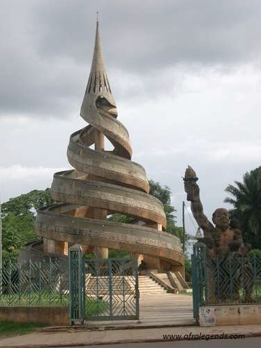
The Reunification Monument in Yaoundé
Yaoundé lies at the center of the nation, at about 600 – 1000 m above sea level. The city first grew around the Mfoundi river. A network of hills make up its landscape such as Mts Mbam Minkom (1295 m), Nkolodom (1221 m), Messa, Fébé, Akokdoué in the North and West, and Mt Eloumden (1159 m) in the south. The rivers are the Mfoundi, Ekozoa, Biyeme, and Mefou. Today, Yaoundé is the siege of power, the presidential palace, the house of parliament, all ministries and embassies. Please enjoy this song of one of Cameroon’s great singers: André-Marie Tala about Yaoundé, and its beauty. What I have always liked about Yaoundé are its hills (and the red soil): from the top of one them, other parts of the city can be seen; it gives a feeling of “breathing in” or “taking in” the beauty of the entire city. Feel the joy of visiting this city which, like Rome has 7 hills. Enjoy the Rome of Africa!
I saw this very good photojournal article on BBC about Nigeria’s many monarchs. I just loved it, because of its depiction of African culture, and the beauty of their heritage. I had to share. From the Ovie of Umiaghwa Abraka kingdom in the Delta State, to the Pere of Isaba kingdom (a kingdom which exists since the 14th century), to the Emir of Zauzau in Kaduna State, this photojournal is rich and depicts the multiple kingdoms and cultures of Nigeria. The author of these, i.e. the photographer is George Osodi, took many years to capture these monarchs in their attire in never before seen images. Enjoy! (Don’t forget to click on the BBC link.)
The Ovie of Umiaghwa Abraka kingdom, Delta State, Nigeria (Source: George Osodi – BBC)
‘Afrikan Alphabets: The Story of Writing in Afrika’ by Saki Mafundikwa
I always thought that the Egyptian hieroglyphs or the yet undeciphered Meroitic alphabet were not the only signs of ancient writing in Africa. I also always thought that there were other forms of writing throughout Africa, and not just in the northern part. So I was happy to hear Saki Mafundikwa, the founder of Zimbabwe‘s first graphic design school and new media, talk about his book Afrikan Alphabets: The Story of Writing in Afrika, which is a comprehensive review of African writing systems throughout centuries. Mafundikwa left a very successful career in New York to return to his home country and open this school, so as to inspire the newer generations of African designers to look inward (to their own rich cultures) as opposed to outward (toward Europe) as they have done in the past decades. He sums it up so well in his favorite Ghanaian glyph, Sankofa, which means “return and get it” — or “learn from the past.” It is refreshing to learn about these systems, from simple alphabets to secret symbols, from the Adinkra of Ghana, to Mende, Vai, Nsibidi, Bamum, Somali, and Ethiopian scripts which date back centuries.
It is above all refreshing to realize that Africans have their own way of thinking which can be perceived in their designs, and that ultimately graphic designs date as far back as the ancient Egyptians and can be observed throughout Africa. Take the time to read Saki Mafundikwa in his own words. Enjoy Saki Mafundikwa’s speech at one of the TED conference.
Today, I would like to talk about the Ishango bone, or rather the first evidence of a calculator in the world. Named after the place where it was found in the Democratic Republic of Congo (DRC), the Ishango bone is what is called a bone tool or the craddle of mathematics. Dating as far back as 22000 years ago, in the Upper Paleolitic era, the Ishango bone is a dark brown bone which happens to be the fibula of a baboon, with a sharp piece of quartz affixed to one end for engraving. It is the oldest attestation of the practice of arithmetic in human history.
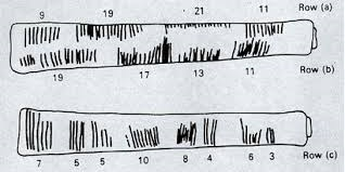
The Belgian geologist Jean de Heinzelin de Braucourt uncovered the bone buried in layers of volcanic ashes on the shores of Lake Edward in the Ishango region in DRC, near the border with Uganda. The Ishango bones are actually two (2) bones of baboon, 10 to 14 cm long, with several incisions on each faces. The smallest of the two bones was the first to be exposed at the Royal Belgian Institute of Natural Sciences in Brussels; it carries several incisions organized in groups of threecolumns.
The location of Ishango
The left columncan be divided in 4 groups, with each group possessing 19, 17, 13, and 11 notches. The sum of these being 60. Those are the 4 successive prime numbers between 10 and 20. This constitutes a quad of prime numbers.
The central columnis divided in groups of 8. By an approximate count, one can find (in the parenthesis, is the maximum number): 7 (8), 5 (7), 5 (9), 10, 8 (14), 4 (6), 6, 3. The minimal sum is 48, while the maximal sum is 63.
The right columnis divided into 4 groups, where each group has 9, 19, 21, and 11 notches. The sum of these 4 numbers is 60.
The second bone has not been well-studied. However, we know that it is composed of 6 groups of 20, 6, 18, 6, 20, and 8 notches.
The Ishango bones with their notches and the numbers
The first bone has been subject to a lot of interpretation. At first, it was thought to be just a tally stick with a series of tally marks, but scientists have demonstrated that the groupings of notches on the bone are indicative of a mathematical understanding which goes beyond simple counting. In fact, many believe that the notches follow a mathematical succession. The notches have been interpreted as a prehistoric calculator, or a lunar calendar, or a prehistoric barcode.
Jean de Heinzellin was the first to consider the bone as a vestige of interest in the history of mathematics. For instance, he noted that the numbers in the left column were compatible with a numeration system based on 10, since he saw that: 21 = 20 + 1, 19 = 20 – 1, 11 = 10 +1, and 9 = 10 -1. These numbers are also prime numbers between 10 and 20: 11, 13, 17, 19.
The Ishango bones with the notches
Some other scientists such as the Belgian physical engineer proposed that the bones were probably a slide rule. While Alexander Marshack has indicated that the bones could refer to the oldest lunar calendar on earth. Claudia Zaslavsky thinks that the author of the Ishango bone must have been a woman following the lunar phases to calculate her menstrual cycle. However, the second bone completely rules out the lunar calendar theory, and favors more the numeration system.
All said, it is amazing to realize that there were mathematicians 20,000 years ago on the African continent. It is so great to realize that my ancestors, on the shores of Lake Edouard, were actually brilliant scientists playing with prime numbers. Whether it was a woman calculating her menstrual cycle, or some brilliant tribe astronomer, it feels so good to know that the paleo-mathematicians of Ishango already knew prime numbers. They were a great civilization long before the pharaohs of Egypt. Thus, in reality, the Ishango bone is the oldest table of prime numbers in the world. To read more, check out Mathematicians of the African Diaspora,, the Prime Glossary, and Wolfram Mathworld.