
Did you know that Africa’s true size has been misrepresented on world maps for centuries, all the way back to the 16th century? The African continent spans over 30 million km2, making it larger than China, Russia, the United States, and Europe combined. On most maps, Africa appears almost 14 times smaller than its actual size, even though it covers more than 20% of the Earth’s land surface.
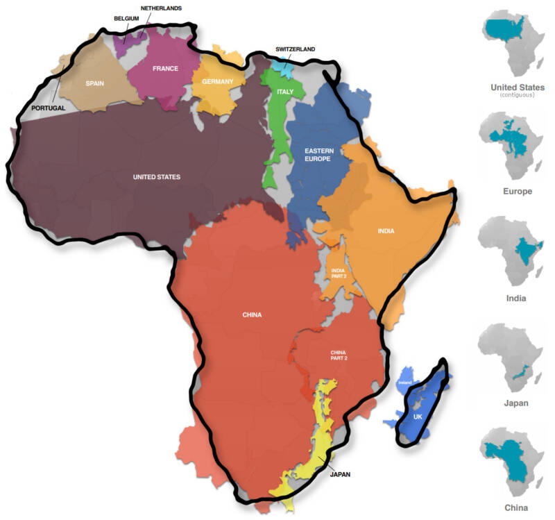
To put it in perspective: you could fit China, India, Mexico, the United States, and Japan inside Africa, and still have room left for several more countries. On the commonly used Mercator projection, Greenland appears larger than Africa, even though Africa is in reality about 14 times bigger. The distortion historically served to make Europe appear larger and more dominant than it truly is.
This Friday, the United Nations General Assembly voted overwhelmingly to support having Africa represented accurately on global maps. Many people say this is not an important issue and that there are more urgent problems in the world. However, this is not a question of importance but a question of scientific accuracy and of re‑establishing the truth. If the situation were reversed, no one would have dared to question it. Fortunately, everyone at the UN agreed today that the record needed to be set straight. Centuries of distortion will finally be corrected, and the world can see the true size of Africa with clarity and honesty. But should this really have needed a UN resolution to be sorted out… is it not normal? I guess for Africa, everything has to be restored, especially the truth!
For more, please check out this article on the BBC.
====
The UN General Assembly has voted to replace the traditional world map with one that more accurately reflects the size of Africa.
The “Correct the Map” resolution, sponsored by Togo and backed by African Union (AU) members, passed with the support of 164 nations, including France and the UK. The United States was the only nation to vote against it – and there were six abstentions.
The UN vote is non-binding but will see changes to the maps used by institutions around the world.
The Mercator map, which has been in common use since the 16th Century, has come in for criticism as it shows Africa as similar in size to Greenland, even though it is 14 times larger.
Critics say this leads to the development needs and potential for countries near the equator to be minimised.
… Ahead of Friday’s vote, Togolese Foreign Minister Robert Dussey told the Reuters news agency: “A fair world begins with a fair map.”
Earlier he had told a UN briefing: “A map is never neutral. It shapes perceptions, influences how the place of peoples and continents in the world is understood.”


