‘Catastrophic’: Sierra Leone Sells Protected Rainforest for Chinese Harbor

Flag of Sierra Leone

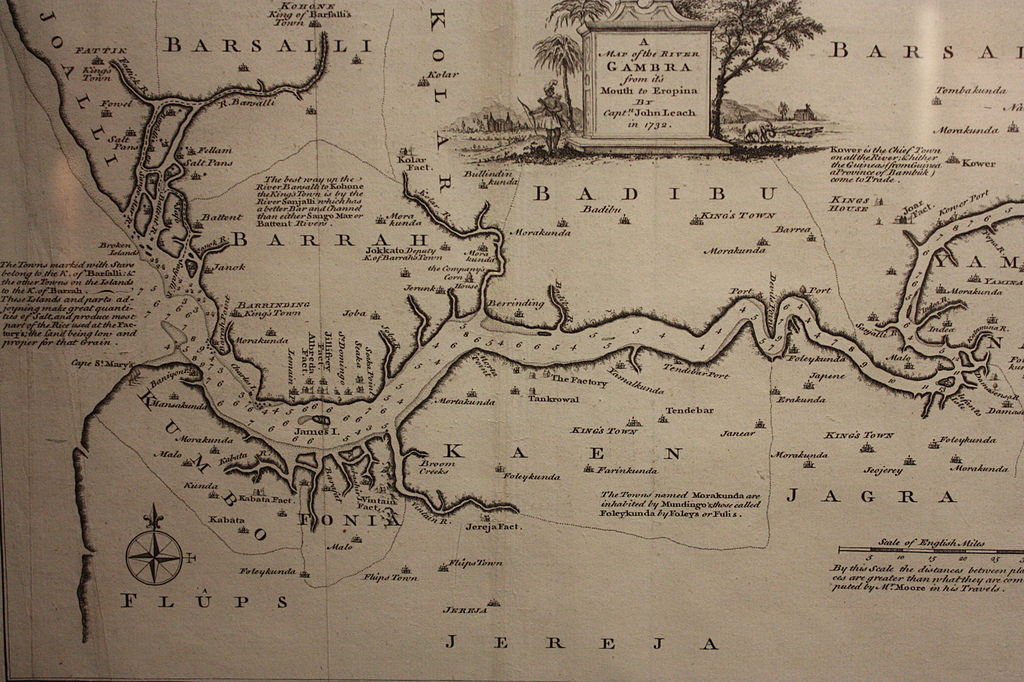
Hundred years after the “signing” of all these lands in Africa to Europeans (we all know it was not a consensual signing as there were threats of war, aggression from other tribes, sometimes bombings, etc), the scramble for Africa, colonization, and more, a new scramble has started again, with lands yet again being “signed” off to foreigners to the detriment of the locals. Below is the recent signing of hundreds of acres of protected land in Whale Bay, in Sierra Leone to Chinese companies. This is a catastrophic story, especially as it will cause an ecological disaster. This is not the only area where it is happening, it is not just in Sierra Leone, and it is not just Chinese companies, but many more … reminiscent of the 999 year land treaty in Kenya [Did You Know about the 999-year Lease granted to Europeans in Kenya ?]… We, Africans, need better laws, better governance, love of our own selves, patriotism, and less corruption. True, we need development, but it cannot be at the expense of ourselves. There are also several questions: is this a land sell, a lease, or what? Can it be overturned? Excerpts below are from The Guardian

====

A $55m (£39m) deal struck by the government of Sierra Leone with China to build an industrial fishing harbour on 100 hectares (250 acres) of beach and protected rainforest has been criticised as “a catastrophic human and ecological disaster” by conservationists, landowners and rights groups.

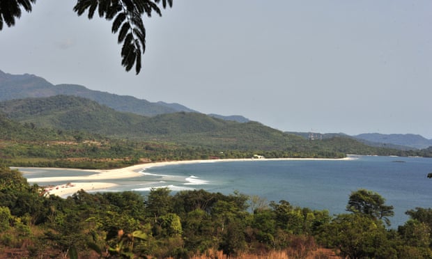
The gold and black sands of Black Johnson beach fringe the African nation’s Western Area Peninsula national park, home to endangered species including the duiker antelope and pangolins. The waters are rich in sardines, barracuda and grouper, caught by local fishermen who produce 70% of the fish for the domestic market.

After reports of a Chinese-backed fishmeal plant began circulating on social media, A statement that appeared to be from the Sierra Leonean fisheries ministry confirmed the deal, but denied the planned construction was a “fish mill”. The facility would be a harbour for tuna and “other bigger fishing” vessels exporting to international markets, it said. It would include a “waste-management component” to “recycle marine and other wastes into useful products”.

The beach earmarked for development fringes the Western Area Peninsula national park, home to endangered species including pangolins. (Source The Guardian: Issouf Sanogo/AFP/Getty)

The government said the beach, one of many along the nation’s 250-mile (400km) coastline, was the “most suitable place” for construction, and revealed the finance ministry had set aside a compensation package of 13.76bn leone (£950,000) for affected landowners. But the statement leaves more questions than answers, say those objecting to the plan.

… “Under the constitution, the government can sequester land if it is in the public interest,” Tonner said. “Even if this just a deep-water harbour, it is not in the public interest because it’s not a suitable site. There are fish breeding sites in the lagoon. It will wipe out the local fish people live on.”

… James Tonner, who owns land at Black Johnson with his mother, Jane Aspden Gbandewa, has written an open letter to the president, Julius Maada Bio, calling for him to intervene and stop the construction, which Tonner said would be “disastrous for the country and the planet”.

It would destroy pristine rainforest, plunder fish stocks and pollute fish breeding grounds and several ecosystems, Tonner said. The beach is on Whale Bay, so-named because whales and dolphins are seen there.

… “Under the constitution, the government can sequester land if it is in the public interest,” Tonner said. “Even if this just a deep-water harbour, it is not in the public interest because it’s not a suitable site. There are fish breeding sites in the lagoon. It will wipe out the local fish people live on.”

… “Our own fishermen won’t have a place to fish. Everything will be spoiled. Tourism will be finished.”

Dr Sama Banya, president emeritus of the Conservation Society of Sierra Leone, echoed Gbandewa’s comments, saying the proposed development would have a “disastrous” impact on tourism and “the very fish industry that it’s supposed to support”. …

How to Sign over a River? : British Colonial Treaties in Africa – The Case of the Gambia River

Map and Flag of The Gambia

As I read more colonial treaties signed on the continent, it is hard for a modern mind to understand the concept of ceding over rivers. How do you know where the river ends? Is the river part of just one kingdom? What do you do when it is split among several kingdoms? Did the Europeans take that into consideration, if they only had the signature from one king, and not others? Or did they just cause war to get the remainder of the river? What do you think?

Below is the example of the Gambia River.

On the 3rd September, 1783, a Treaty was concluded between Great Britain and France, by Article X of which the King of the French guaranteed to the King of Great Britain the possession of Fort James (Albreda) [located on modern-day Kunta Kinteh Island] and of the River Gambia.

====

Cession of the River Gambia to Great Britain. (The map of Africa by Treaty, Vol 1, P.367 – 368)

On the 15th June, 1826,+ a Convention was signed between the Acting Governor of Sierra Leone and the King of Barra and of the River Gambia, with his Chiefs and headmen, for the cession of the Gambia to Great Britain.

Map of the River Gambra (now Gambia) in 1732

It contained the following stipulations:

* * *

“ 2nd. The said Brunay, King of Barra, by and with the advice and consent of his Chiefs and headmen before named, cedes, transfers, and makes over to his Honour Kenneth Macaulay, Acting Governor of  Sierra Leone, and his successors, Governors of Sierra Leone for the time being, on the part and behalf of His Majesty the King of the United Kingdoms of Great Britain and Ireland, his heirs, and successors forever, the full, entire, free, and unlimited right, title, sovereignty; and possession of the River Gambia, with all the branches, creeks, inlets, and waters of the same, as they have been held and possessed by the Kings of Barra from time immemorial ; and the said Brunay, King of Barra, with the advice and consent of his said Chiefs and headmen as aforesaid, does further cede and forever relinquish all and every right, claim, or demand for customs or duties of any description on British or other vessels entering or navigating the River Gambia, or any of the waters thereof (as have been formerly demanded and taken).

+ S.P., vol. xlviii, p. 882; H.T., vol. xii, p. 5. See also Treaties, 6th January, 1832, p. 824, and 18th November, 1850, p. 326.

15-Year-Old Sierra Leonese Inventor Wowing MIT

Sierra Leone_flag
Flag of Sierra Leone

This is old news, but I am still in awe with this kid and had to share it with you. Meet then 15 years-old Sierra Leone boy, Kelvin Doe, who wowed MIT! Enjoy! He is very creative: he created his own battery because of electricity shortage, he made his own radio because he wanted to broadcast to people in his neighborhood, he made his own generator because he needed it. He works by reverse engineering. Enjoy!

Why the name: Liberia?

Liberia
Liberia

What comes to mind when you hear the name of the country Liberia? … Liberty, freedom?

Exactly, the colony of Liberia was started by the American Colonization Society (ACS) in 1820 which repatriated free slaves from the United States to Liberia.  Why exactly was that territory chosen versus any other is a mystery.  I suspect that it was just a replica of what the British were doing, as they had started repatriating free slaves from Nova Scotia (Canada) to Sierra Leone as early as 1792.  It is therefore no surprise that Liberia is a neighboring country to Sierra Leone.  On July 26, 1847, the free slave settlers issued a Declaration of independence (modeled after that of the US), and created the Republic of Liberia, with its capital Monrovia named after the American president James Monroe, one of the supporters of the ACS.

Flag of Liberia
Flag of Liberia

However, before the arrival of the 500+ free slaves from America, modern-day Liberia was located in an area known as the Pepper Coast or Grain Coast (La côte des graines) or Melegueta Coast in honor of the grains of paradise or melegueta pepper, a very common in West African cuisines.  The Portuguese actually named it Costa da Pimenta, meaning Pepper Coast, in the 1500s.  The area was inhabited by Mende people, Dei, Bassa (not to be confused with the Bassa people of Cameroon), Kru, Gola, and Kissi people.  The Pepper Coast has been inhabited at least as far back as the 12th century and perhaps earlier.

Mme President
President of Liberia: Mrs. Ellen Johnson Sirleaf

There was actually a clash between the free African Americans who came to identify themselves as Americo-Liberian, and the local indigenous people.  The Americo-Liberians developed a culture based around American notions of superiority and racial supremacy: they felt superior to the indigenous people.  This was probably at the root of the Liberian civil wars which lasted several years.  As Liberia struggles to heal the wounds of war, it is making big steps toward democracy, peace, and freedom.  It was also the first country in Africa to elect a woman president: Mrs. Ellen Johnson Sirleaf.

Today, as you enjoy the video below on Liberia, I would like to ask a question: with all the wars and political instabilities seen in Liberia, has the country’s name affected its history or destiny? Has its name been a curse or a blessing?

Sierra Leone: Why the Name?

Modern-day Freetown
Modern-day Freetown, the capital of Sierra Leone

I always thought the name of the country Sierra Leone was rather strange: how could a predominantly Muslim, English-speaking, African country have an Italian name?  There was never an Italian presence in that region of Africa.  So why in the world, is an ex-British colony with slaves returning from America, slaves who had fought on the British side during the American revolutionary war from 1775 to 1783, carrying an Italian name, and what does it mean?

Freetown, Sierra Leone, in 1856

Well, in 1462, the Portuguese explorer Pedro de Sintra sailing down the West African coast, saw the tall mountains rising from what is now Freetown peninsula or harbor, and named the area ‘Serra de Leão,’ which means ‘mountains of the lion’, or ‘hills of the lion,’ because of the shape formed by the hills surrounding the harbor.  The  rendering of this geographic formation is Sierra Leone, Leone being the Italian for Lion, while Sierra is Spanish for hills or mountain, thus the name. In reality, it is said that it was leona in Spanish which was accidentally changed to Leone; so the origin should be Spanish. Sierra Leone has the third largest natural harbor in the world.  Archaeologically, that area has been inhabited continuously for the past 2500 years, from successive movements from other parts of Africa.  In 1495, the Portuguese established a port there, and were later joined by the Dutch and French, who used the area as a slave trading point.  In 1787, a first settlement of those called Black poors was founded in the Province of Freedom.  They were later decimated by the indigenous population.  A second settlement came in composed of Nova Scotian settlers, and Jamaican Maroons.  Sometime, at the beginning of the 19th century, Sierra Leone became a British colony.  Sierra Leone today is a true melting pot of Temne, Mende, Limba, Fula, Mandingo, Kono, and Krio (descendants of African American, West Indies slaves, etc) people.  In 2006, the country was featured in the movie Blood Diamond with Leonardo DiCaprio.

So there goes the story of a British colony, English-speaking country, predominantly Muslim, with an Italian name in an area where no Italian explorer had set foot.  Enjoy this video on Freetown, the capital of Sierra Leone.