The Khami Ruins: Remnants of a Great Civilization in Southern Africa

Location of Khami Ruins in Zimbabwe

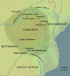
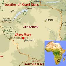
Today we will be talking about the remnants of a great stone civilization in southern Africa: the city of Khami. The Khami Ruins are the remnants of the capital city of the Kingdom of Butua of the Torwa dynasty . It is located on the west bank of the Khami river, 22 km west of Bulawayo in southern Zimbabwe. It was the capital of the Torwa dynasty for about 200 years from AD 1450 to AD 1644. It emerged at the time of the disappearance of Great Zimbabwe.

Khami Ruins (WHC-UNESCO website)

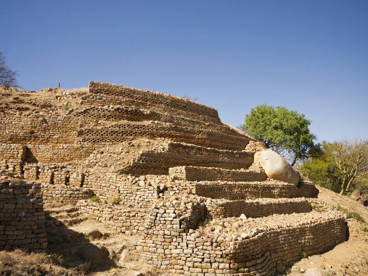
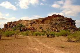
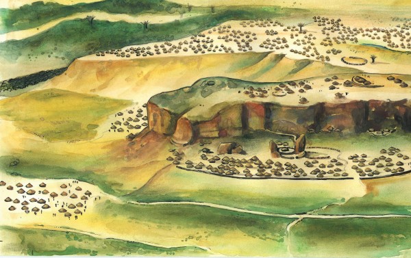
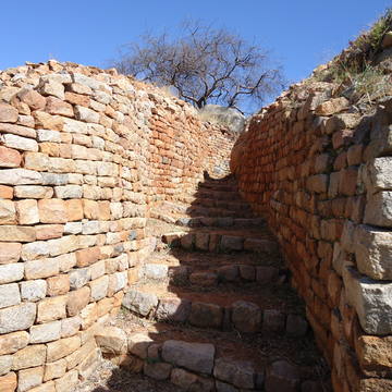
Today, the site of the Khami ruins is a national monument and a UNESCO World Heritage Site since 1986. The site is dominated by a series of terraced stone ruins, often highly decorated. It reveals seven built-up areas occupied by the royal family with open areas in the valley occupied by the rest of the population. The complex comprises circular, sometimes terraced, artificial platforms encased by dry stone walls. The beautifully decorated 6m-high by 68m-long retaining wall of the Precipice ruin bears a checkerboard design along its entire length. The imposing front façade marked the main entrance. The Precipice Ruin was a ritual center with the longest decorated stonewall of its kind in the entire sub-region. Nearby are the Cross Ruin with its mysterious stone Dominican Cross, believed to have been placed by a contemporary missionary, and the Northern Platform once used to process gold. The nearby Passage Ruin consists of two adjoining semicircular platforms accessed by a narrow passageway. The platforms, rising 2-7 m above ground, carried clay huts and courtyards where the rest of the populations lived. The remnants of cattle kraals and huts for ordinary people can be seen from the Hill Complex. The ruins include a royal enclosure forming the Hill Complex located on higher grounds, stone walls and hut platforms. There are also ruins on the eastern side of the Khami River.

A wall at the Khami ruins showing the herringbone and chessboard patterns
A wall at the Khami site showing the herringbone and checkerboard patterns

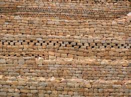
To build the structures at Khami required engineering and architectural feats, since the stone found at Khami (laminar granite) was different from that found in other areas of Zimbabwe (biotite). This stone was harder to quarry and produced shapeless building stone; over 60% of the stone produced at these quarries would not have been of building quality. The building blocks thus needed to be shaped, but even then the stones were not suitable for building free-standing dry stone walls. The builders of Khami thus made an innovation and produced retaining walls instead. Moreover, building platforms made the houses cooler than those in the open areas below. Khami’s architecture conforms to that of Great Zimbabwe in a number of archaeological and architectural aspects but it possesses certain features particular to itself and its successors such as Danangombe and Zinjanja. Retaining walls and elaborate decorations were first expressed in the architectural history of the sub-region at Khami.

Artist rendition of what the city of Khami would have looked like (historum.com)

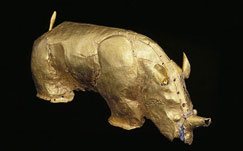
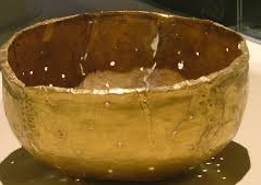
Archaeological finds include 16th century Rhineland stoneware, Ming porcelain pieces which date back to the reign of Wan-Li (1573-1691), Portuguese imitations of 17th-century Chinese porcelain, 17th-century Spanish silverware, etc. These indicate that Khami was a major centre of trade, presumably linked (like Mapungubwe and Great Zimbabwe before it) to the Swahili ports on the East Africa coast.

A passageway at Khami (WHC-UNESCO website)

Unfortunately, Khami was invaded by Changamire Dombo, around 1683, who led a Rozwi army from the Mwenemutapa (Monomotapa) state. The Rozwi made Danangombe (Dhlo-Dhlo) another area of the Khami site as the new capital of their empire, the Rozwi Empire. In the 1830sNdebele raiders displaced the Rozwi from Khami. A small site museum provides useful background information to the site itself. If you are ever in the vicinity, do not forget to visit this amazing site, remnant of a great stone civilization.


Ancient Civilizations of Southern Africa: The Kingdom of Mapungubwe

Map of Mapungubwe
Map of the area including the Kingdom of Mapungubwe and Great Zimbabwe to the north- and the whole Kingdom of Zimbabwe (sahistory.org.za)

After talking about the origin of the name of the country Zimbabwe, named after Great Zimbabwe, the capital of the Kingdom of Zimbabwe which flourished in southern Africa from the 13th to 17th century, I thought it only wise to talk about some of the kingdoms that flourished in that area, starting with the Kingdom of Mapungubwe, a predecessor to the Kingdom of Zimbabwe. The Kingdom of Mapungubwe was a rich iron age civilization that flourished in the area of modern-day Zimbabwe, Botswana, and South Africa, from the 10th to the 13th century AD. It was a pre-colonial state located at the confluence of the Shashe and Limpopo rivers. The kingdom’s development culminated in the creation of the Kingdom of Zimbabwe in the 13th century, as a normal evolution of itself, and with gold trading links to Rhapta and Kilwa Kisiwani on the African east coast.

Mapungubwe Hill (Wikipedia)

From archaeological searches, the people of Mapungubwe were of the Venda and Kalanga people ancestry, and were attracted to the Shashe-Limpopo area because of its fertile soils for agriculture, and also because it was an area rich with elephants, thus rich with ivory. The area of Mapungubwe was also rich in gold, and the people traded in gold and ivory, snail shells, pottery, wood, and ostriches’ eggs (eggshells), with places as far as Egypt, Persia, India, and China.

An artist impression of Mapungubwe (Source: newhistory.co.za)

Stone walls were used to demarcate important areas, and important residences were built with stone and wood. Life in Mapungubwe was centered around family and farming. The kingdom, as well as the way people lived, was divided into a three-tiered hierarchy, with the commoners inhabiting low-lying sites, district leaders occupying small hilltops, and the kingdom’s elites residing at the capital at Mapungubwe hill as the supreme authority. Important men maintained prestigious homes on the outskirts of the capital.

Bateleur Eagle on the flag of Zimbabwe

The kingdom was named after its capital city, the city of Mapungubwe. Several theories have been put forward for the meaning of the name itself. For some, Mapungubwe means “place of Jackals,” or “place where jackals eat,” or “hill of jackals.” In Shona, the language spoken by the majority of people in Zimbabwe, Mapungubwe means “rocks of the Bateleur eagle,” a bird which has deep spiritual connotations in the Shona culture (ma = many; pungu =suffix for chapungu = bateleur eagle, the massive bird which once graced the entrance of the royal complex of Great Zimbabwe; bwe = diminutive for ibwe = stone).

Mapungubwe's famous gold foil rhinoceros (Source: Univ. of Pretoria)
Mapungubwe’s famous gold foil rhinoceros (Source: Univ. of Pretoria)

The site was rediscovered in 1932. At the top of Mapungubwe, they found many golden objects: bangles, beads, nails, miniature buffalo, rhino, a skeleton, and gold anklets, about 2.2 kg of gold and many other clay and glass artifacts. Between 1933 and 1998, the remains of about 147 individuals were excavated from the Mapungubwe Cultural LandscapeThese findings were kept quiet for a long time, as they provided contrary evidence to the racist ideology of black inferiority underpinning apartheid.

Golden bowl found at Mapungubwe (golimpopo.com)

So any time you think about southern Africa only being populated by pastoralists, nomadic peoples, think again. There were very rich, and strong empires, such as the kingdom of Mapungubwe which was the first major iron age kingdom in Southern African, and traded with places as far as Egypt, Persia, India and China. For more information, check out the very rich Mapungubwe National Park website, South Africa.info, the Metropolitan Museum (MET) article, South African History Online, the Mapungubwe Kingdom website, and the UNESCO World Heritage website as Mapungubwe is listed. Enjoy the video below!