Why the Name: Gaborone?

'The No1 Ladies Detective Agency' by Alexander McCall Smith
‘The No1 Ladies Detective Agency’ by Alexander McCall Smith

Many of you have probably heard about Gaborone, the capital of Botswana, from the book series, The No. 1 Ladies’ Detective Agency, by Alexander McCall Smith.  The series follows Precious Ramotswe, the first female private detective in Botswana, and the mysteries that she solves; her agency is based in Gaborone.  Have you ever stopped to wonder what the name Gaborone actually meant?

Map of Botswana (Lonely Planet)
Map of Botswana

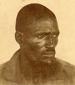
Gaborone was the name of the Chief of the Batlokwa, Kgosi Gaborone, who left the Magaliesberg to settle in the area around 1880, and called the settlement Moshaweng.  Moshaweng meant ‘place where the river’s sand has washed out.’  Today, Moshaweng has been renamed Tlokweng, or Place of the Batlokwa, and is located on the east of the Notwane river, facing the Village.  Gaborone was then known as Chief Gaborone’s village.  His name itself, Gaborone, meant ‘it does not fit badly or ‘it is not unbecoming.’  The city was then called Gaberones by European settlers.  Tlokweng was across the river from the Government Camp, the name of the British colonial headquarters.  In 1890, Cecil John Rhodes picked Gaberones to house a colonial fort.  The fort was where Rhodes planned the Jameson Raid.

Aerial View of Gaborone

In 1965, the capital of the Bechuanaland Protectorate was moved from Mafeking in South Africa to Gaberones.  When Botswana gained independence on 30 September 1966 from Great Britain, Lobatse was considered as the first choice for the nation’s capital.  However, Gaberones was chosen over Lobatse because of its proximity to fresh water, its proximity to the railway to Pretoria (South Africa), its central location among the central tribes, and its lack of association with those surrounding tribes: it was a sort of ‘neutral ground.’  The city changed its name from Gaberones to Gaborone in 1969.  Meanwhile, Chief Gaborone had died in 1932, aged about 106 years old; he never saw the capital of his country take his name.

National Assembly of Botswana (in Gaborone)

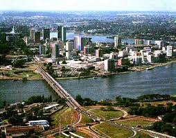
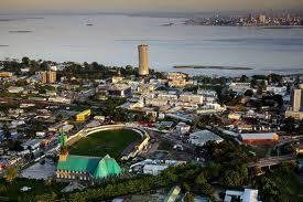
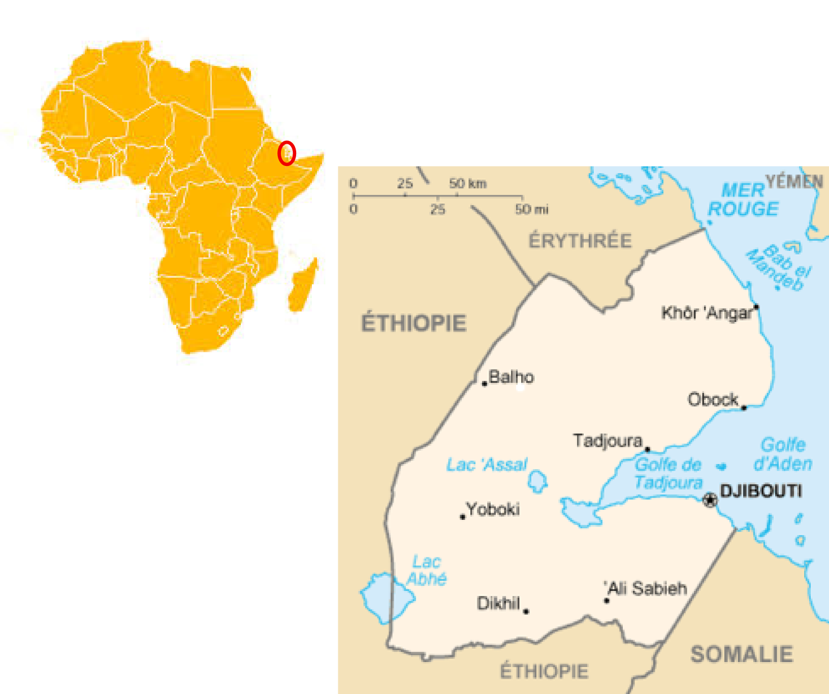
Geographically, Gaborone is situated between Kgale and Oodi Hills, on the Notwane River in the southeastern corner of Botswana, and just 15 km from the South African border.  The city lies at an elevation of 1,010 m above sea level.

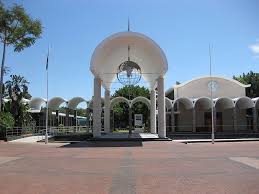
Today, Gaborone is rapidly growing.  It is currently home to over 250,000 people.  It is a very vibrant city, and is one of the fastest growing cities in the world.  Nowadays, Gaborone is called the “White City” and is nicknamed “Gabz” by locals.  Enjoy the video below on Gaborone!


Why the Name: Addis Ababa?

Map of Ethiopia
Map of Ethiopia

I have often wondered about the meaning of the name Addis Ababa or Addis Abeba, the capital of Ethiopia.  The name always sounded so poetic, and full of beauty somehow.

You can imagine my surprise when I found out that the name of the largest city of Ethiopia, Addis Ababa or Addis Abeba, actually meant “New Flower.”  No wonder the sound of it was always so pretty.

The region where Addis Ababa is founded is called Finfinne, or Natural Springs, by the local Oromo population; it is an area rich with fauna and flora.  In the southwest, can be found Mount Wachacha, and in the north Mount Entoto.  Before the foundation of Addis Ababa, Emperor Menelik II and the empress Taytu Betul were installed in the area of Mount Entoto as it was used a military base for operations in the south of the realm; however that area had a rude climate, was cold, and very windy.  So the imperial couple used to visit the thermal sources of Filwoha, hot mineral springs, located at a lower altitude.

Empress Taytu Betul
Empress Taytu Betul

In 1886, while Empress Taytu Betul was admiring the landscape, she saw a flower of rare beauty.  Enchanted by the nice climate, she asked her spouse, Emperor Menelik II, to build her a house in the area.  Menelik II agreed and promised Taytu to build her a residence there.  The choice of the precise location of Addis Ababa followed the prophecy of Menelik II’s grandfather, Sahle Selassie, Negus of Shewa from 1813 to 1847.  During a game of chess, Sahle Selassie declared: “This country is covered with scrub and vegetation, but the day will come when my grandson will build a house here, and will found a city.”  Menelik II founded the city at the exact location where his grandfather was practicing fencing.  The name was Empress Taytu’s choice: she had been stunned by that beautiful flower she had never seen before, hence she named the city Addis Ababa, or “New Flower” in Amharic.

Emperor Menelik II
Emperor Menelik II

Menelik expanded his wife’s house to become the Imperial Palace which remains the seat of government in Addis Ababa today.  Addis Ababa became Ethiopia’s capital when Menelik II became Emperor of Ethiopia.  The town grew by leaps and bounds.  One of Emperor Menelik II’s contributions still visible today is the planting of numerous eucalyptus trees along the city’s streets.  The city lies at an altitude of 2300 meters, and is a grassland biome.

Following all the major engagements of their invasion, Italian troops from the colony of Eritrea entered Addis Ababa on 5 May 1936.  Along with Dire Dawa, the city had been spared the aerial bombardment (including the use of chemical weapons such as mustard gas) practiced elsewhere and its railway to Djibouti remained intact.  The city served as the Duke of Aosta‘s capital for the unified colony of Italian East Africa until 1941, when it was abandoned in favor of Amba Alagi and other redoubts during the Second World War‘s East African Campaign.  The city was liberated by Major Orde Wingate‘s Sudanese and Ethiopian Gideon Force in time to permit Emperor Haile Selassie‘s return on 5 May 1941, five years to the day after he had left.

Emperor Haile Selassie

Following reconstruction, Haile Selassie helped form the Organisation of African Unity in 1963 and invited the new organization to keep its headquarters in the city.  The OAU was dissolved in 2002 and replaced by the African Union (AU), also headquartered in Addis Ababa.  The United Nations Economic Commission for Africa also has its headquarters in Addis Ababa.  It is home to Addis Ababa University.  The Federation of African Societies of Chemistry (FASC) and Horn of Africa Press Institute (HAPI) are also headquartered in Addis Ababa.  Ethiopia has often been called the original cradle of humanity due to various humanoid fossil discoveries like the Australopithecine Lucy.  Recent DNA evidence have suggested origins in south central Ethiopian regions like present-day Addis Ababa: after analyzing the DNA of almost 1,000 people around the world, geneticists and other scientists claimed people spread from what is now Addis Ababa 100,000 years ago.  Enjoy video about the new flower, and all its cultural wealth.

Why the Name: Cairo?

Map of Egypt
Map of Egypt

Dear all, today, I would like to talk about the city of Cairo, the capital of Egypt.  Have you ever wondered what the name of Africa‘s second most populous city, after Lagos, stood for?

Old Cairo, 1900s, Fustat
Old Cairo, ca early 1900s, Fustat

Well, Cairo’s official name is al-Qāhirah, which means literally: “Place or Camp of Mars“, in reference to the fact that the planet was rising at the time of the city’s foundation as well as, “the Vanquisher“; “the Conqueror“; “the Victorious” or, “the Strong” (al-Qahira) in reference to the much awaited Caliph Al-Mu’izz li-Din Allah who arrived from the old Fatimid capital of Mahdia in 973 AD to the city.   “The Victorious” is often quoted as the most popular meaning of the name Cairo.  The Egyptian name for Cairo is said to be: Khere-Ohe, meaning: “The Place of Combat“, supposedly, in reference to a battle which took place between the Gods Seth and Horus. Sometimes the city is informally also referred to as كايرو Kayro [ˈkæjɾo]. It is also called Umm al-Dunya, meaning “the mother of the world“.

Modern-day Cairo
Modern-day Cairo

Cairo is located on the shores of the Nile river, as well as on several adjacent islands in the north of Egypt.  To the west of the city is Giza, and its ancient necropolis of Memphis on the Giza plateau, with its three great pyramids among which the Great Pyramid of Cheops and the Great Sphinx.  The area around present-day Cairo, especially  Memphis, had long been a focal point of Ancient Egypt, its pharaohs, and its rich culture, due to its strategic location upstream from the Nile Delta.  However, the origins of modern-day Cairo are generally traced to a series of settlements in the first millenium, as Memphis’ importance was declining.  In the 4th century AD, the Romans established a fortress town, known as Babylon, along the east bank of the Nile. This fortress remains the oldest structure in the city to this day. Later on, the Caliph al-Mu’izz li Din Allah of the Fatimid dynasty moved his capital from Mahdia in Tunisia to Cairo in 973; and gave the city its present name, al-Qahira (“The Victorious“).  Cairo remained the capital through the end of the Fatimid dynasty 200 years later, and has remained the capital of Egypt through the Ottoman rule, and into the modern era.

The Great Sphinx of Giza

Indeed, Cairo’s life has been quite victorious.  Egypt is the land of so many rich civilizations: the great Pharaohs of Egypt, the Greeks, Babylonians, RomansMuslims with the introduction of Islam; thus Cairo inherited from this wealth and has been a great melting pot.  Egypt as a whole, and Cairo in particular, is like an open museum with monuments reflecting different periods of the world’s history.  As Africa’s second largest city, Cairo is a vibrant city, with the oldest and largest film and music industries in the Arab world, and the world’s second oldest institution of higher learning, al-Azhar University founded in 969 AD.

Please enjoy this great city, Cairo, the Victorious, and hopefully think of visiting it.

Why the Name: Abidjan?

Abidjan
Abidjan

After walking on the sandy beaches of Abidjan, I have often romanticized the name of such a beautiful place, and no matter how much intellectual gymnastics I did, I could never decipher its meaning.  After all, I do not speak the local language, but I somehow thought that it could have been a French name with some local texture to it; but which one?

Map of Côte d'Ivoire
Map of Côte d’Ivoire

Well, according to oral tradition of the Ébrié people as reported in the Encyclopedic Dictionary of Côte d’Ivoire, the name “Abidjan” results from a misunderstanding.  Legend states that an old man carrying branches to repair the roof of his house met a European explorer who asked him the name of the nearest village.  The old man who did not speak the language of the explorer, thought that he was being asked to justify his presence in that place.  Terrified by this unexpected meeting, he fled shouting “min-chan m’bidjan“, which means in the Ébrié language: “I return from cutting leaves.”  The explorer, thinking that his question had been answered, recorded the name of the locale as Abidjan.

La ville d'Abidjan
La ville d’Abidjan (source RFI)

A slightly different and less elaborate version of the legend is as such: When the first colonists asked native women the name of the place, the women misunderstood and replied “T’chan m’bi djan“: “I’ve just been cutting leaves“. Thus the name Abidjan.

Originally a fishing village, Abidjan was made the capital city of the French colony after a deadly epidemic of yellow fever decimated the French colonists in 1896 in Bassam.  In 1934, Abidjan became the third capital of Côte d’Ivoire after Grand-Bassam and Bingerville.  It offered more opportunities for trade expansion, particularly with its greater wharf.  In 1983, the capital was moved to Yamoussoukro, the village of then-president Félix Houphouët-Boigny.  However, Abidjan has remained the political and economic heart of the country.

Aerial view of Abidjan (Source: raymondadrienne.blogspot.com)

Today, Abidjan is Côte d’Ivoire’s largest city, and the third largest French-speaking city in the world after Paris and Kinshasa.  The city is located in the Ébrié Lagoon on several converging peninsulas and islands connected by bridges.  Abidjan is considered a cultural hub for most of West Africa, and Francophone Africa in particular.  It has the biggest port in West Africa, and second largest port of Africa after the Lagos port in Nigeria.  With the political unrest of the past decade which reached its paroxysm in 2011 with the French army bombing strategic places in Abidjan in order to impeach President Laurent Gbagbo (including the presidential palace), the city has been destroyed, and is today going through a rebuilding phase.

Affectionately nicknamed the “Manhattan of the tropics“, “Small Manhattan“, or “Pearl of Lagoons“, because of its impressiveness, Abidjan is a unique city perfect for business tourism.  The place is so beautiful, that the French once considered making Côte d’Ivoire an overseas department of France; it is not so far from it today, but that will be the subject for another day.  The video below is on Côte d’Ivoire as a whole.  Enjoy!

Why the name: Brazzaville?

Map and Flag of the Republic of Congo

I always wondered where the name Brazzaville came from.  At first glance, it would appear to mean “the city of Brazza (la ville de Brazza).”  Is this a good guess? and if so, who was Brazza for his name to be given to the capital of an African country.  Fortunately or unfortunately, during European colonization, many African cities, and cities throughout the world, were renamed after the first European explorer passing by or after some European ruler.  Examples are countless: Leopoldville (modern-day Kinshasa), Port Louis (capital of Mauritius, named after Louis XV), Northern and Southern Rhodesia (Zambia and Zimbabwe resp. – named after Cecil Rhodes), etc. Other cities have seen their names ‘europeanized’ such as Canton (Guangzhou, in China), Bombay (Mumbai, in India), and many others.

Savorgnan de Brazza (by Paul Nadar)
Pierre Savorgnan de Brazza (by Paul Nadar)

Brazzaville is the capital and largest city of the Republic of Congo.  It is located on the shores of the Congo River.  It is the only capital in the world facing another one, Kinshasa, the capital of the Democratic Republic of Congo: Brazzaville and Kinshasa are separated only by the Congo river.  The Pool region and surroundings of Brazzaville had been an African crossroad for centuries.  In the Lari language, the regions of Mfoa and Mpila were known under the name Mavula, or “the place to get rich.”  Laris people still refer to Brazzaville that way; however the name Mavula is anachronic since in 1880, the region’s inhabitants were Bateke.  The site of the future capital was known as Nkuna, and was a Batéké village.  Brazzaville was founded on 10 September 1880 by an Italo-French explorer,  Pierre Savorgnan de Brazza, after whom the city was named, Brazza-ville or the city of Brazza.  The local leader, Makoko of the Téké, signed a treaty of protection with de Brazza which subjugated his lands to the French Empire (he was probably fooled by the French, as was common practice with the colonizers).  The city was built four years later in order to become a competitor with Léopoldville (now Kinshasa) which was built by the Belgians on the other side of the river.  The site was occupied from October 1880 until May 1882 by a small squad of troops led by Senegalese Sergeant Malamine Camara, who prevented the land from falling into Belgian hands.

Malamine Camara
Malamine Camara

It was actually Malamine Camara who created links with the local populations, and made them sign with the French.  Malamine was very loyal, and when Savorgnan left for France for a few years, Malamine stayed behind, and convinced the local populations through his good manners to side with the French.  It is so sad that today, history mostly remembers Savorgnan de Brazza, and that even that capital is named after him, when it was the Black Senegalese soldier who fought for the French, led the troops, and convinced the locals.

Aerial View of Brazzaville

The French officially established control over the area by the Berlin Conference of 1884.  The city became the capital first of the French Congo, and then of French Equatorial Africa, a federation of states which encompassed Gabon, the Central African Republic and Chad.  In 1924, the Congo-Océan railway was brought into service which linked Brazzaville with the port of Pointe-Noire.  During World War II Brazzaville, and the rest of French Equatorial Africa, remained beyond the control of Vichy France.  In 1944, Brazzaville hosted a meeting of the Free French forces and representatives of France’s African colonies.  The resulting Brazzaville Declaration was intended to redefine the relationship between France and its African colonies after the war.

Today, Brazzaville is a bustling city of more that 1.5 million inhabitants.  Affectionately called Brazza, it is the heart of the Republic of Congo.   To learn more about Savorgnan de Brazza himself, check out Brazza.culture.fr.  Enjoy, Brazza!


Why the name: Malawi?

Malawi
Malawi

I have been thinking about the meaning of the name Malawi for a while now.  For starters, Malawi is a country located in southern Africa, and it is the second country in Africa to have a female President, Joyce Banda.  So what does Malawi mean?

The origin of the name Malawi is a bit uncertain; it was originally attributed to the lake itself: Lake Malawi.  However, its origin is believed to be linked to the ancient Kingdom of Maravi which flourished in the area in the 15th century AD.  In reality, Malawi means ‘Fire flames‘, evoking the rising sun scintillating on the waters of the lake.  This is clearly drawn on the flag of the country.

Flag of Malawi
Flag of Malawi

Malawi is a landlocked country bordered by Zambia, Tanzania, and Mozambique.  It is a country of high plateaux, with the Shire Highlands in the South, and the Nyka uplands in the north.  The Great Rift Valley runs through the country from north to south.  Lake Malawi, Africa’s third largest lake and second deepest, runs to the east of the valley.  The total area of the lake occupies approximately 20% of the country, and forms its eastern border with Mozambique and Tanzania. Lake Malawi is affectionately called the Lake of Stars.

Lake Malawi
Lake Malawi

The first Europeans in the regions were Portuguese in the 16th century, and later on David Livingstone made it up the Shire River up to Lake Malawi in 1859 to establish a British presence in the region.  The lake was then called Lake Nyasa, with Nyasa meaning Lake in Yao language.  In 1891, the British established the British Central Africa Protectorate, which included Malawi and the protectorate was renamed Nyasaland in 1907.  The country gained independence from the British on 6 July 1964, renamed itself Malawi, with Hastings Kamuzu Banda as president.  Lilongwe is the capital of Malawi, and is located in the central region of the country.  The country’s currency is the Kwacha, which means ‘dawn‘ in local Nyanja and Bemba languages.

Malawi is affectionately known as the warm heart of Africa. Enjoy the fire flames country located in the highland of southeastern Africa, between Zambia, Mozambique, and Tanzania.


Why the name: Djibouti?

Map of Djibouti
Map of Djibouti

Ever wondered why a country would be carrying the same name as its capital city?  Well … I always wondered what was the meaning of Djibouti, and then why the country carried the same name as its capital city.

Located in the coastal Djibouti region on the Gulf of Tadjoura, Djibouti is known as the Pearl of the Gulf of Tadjoura.  The origin of the name Djibouti is very controversial.  However, there are two versions which are more or less plausible.

The first one is based on an ancient Issa legend whereby the name Djibouti (Jab Bouti) came from a fabulous animal Bouti which used to live in those areas and was a ferocious beast killing goats, and sheeps, and terrorizing people.  After a relentless hunt, the men defeated the beast, and named the area Jab Bouti or the Bouti’s defeat.

The second version comes from the Afar people.  The Afar named the current region of Djibouti Gabood for plateaux or uplands; there is the thought that the Afar word gabouti, meaning “plate“, was possibly referring to the geographical features of the area. The Arab sailors called it Gabouti, and later on, the French turned it into Djibouti.

Djibouti in 1940 (Source: Wikimedia Commons)

As you read these two versions, you realize quickly that Djibouti is the land of two main groups: the Issa and the Afar.  From 1860 to 1894, the region north of the Gulf of Tadjoura was known as Obock, and was ruled by Issa Somali, and Afar Sultans, with whom the French signed several treaties to start the colonization of the area.  That is why they (the French) later (between 1967 and 1977) called it the French Territory of the Afars and Issas (Territoire Français des Afars et des Issas (TFAI)).  The French founded Djibouti city in 1888, and later made it the capital of French Somaliland in 1896.  In the 1900s, the city considerably grew in size thanks to the construction of the Imperial Ethiopian Railway which linked Djibouti to southern Ethiopia and the Ogaden.

Djibouti, today (Placesbook.org)

Djibouti city is strategically positioned near the world’s busiest shipping lanes (the Red Sea and the Gulf of Aden) and acts as a refueling and transshipment center.  The Port of Djibouti is the principal maritime port for imports to and exports from neighboring Ethiopia.  Additionally, the city hosts a number of foreign embassies, foreign military bases (French, American, German, Japanese, etc), and is the headquarters of many international organizations, non-profit organizations and companies. Djibouti-Ambouli International Airport is the main domestic airport, connecting the capital to various major global destinations.  Since 1977, the city has served as the capital of the Republic of Djibouti.  Together with northern Somalia, Eritrea, and the Red Sea territory of Sudan, the Republic of Djibouti is thought to be the most likely location of the land known to ancient Egyptians as Punt (the “Land of Tehuti“, or “Land of Thoth“, after the Egyptian Moon God), a kingdom which had close ties with Ancient Egypt during the reign of Pharaoh Sahure and Queen Hatshepsut.

As I live you with this video of the pearl of Gulf of Tadjoura, Djibouti, I would like to ask this question: which of the two legends, in your opinion, is closer to the real origin of the name Djibouti? 

Why the name: Tripoli?

Tripoli, capital of Libya (Source: scoopempire.com)

I always wondered why the capital of Libya was named Tripoli.  The name did not sound so ‘Arabic’ or ‘Berber’ to me… and I always thought that maybe the name had some Italian origin, since Libya was once part of the Roman empire, and later in the 19th/20th centuries an Italian colony.

Tripoli, or Tarabulus in Arabic, is known as Tripoli-of-the-West, to distinguish it from its ancient Phoenician sister city of Tripoli in Lebanon which means Levantine Tripoli or Tripoli of the East.  Tripoli, Libya, is affectionately called the Mermaid of the Mediterranean (arusat-el-bahr: bride of the sea) describing its turquoise waters and its whitewashed buildings.  In reality, Tripoli is a Greek name which means “Three Cities(Tria for three, Polis for city) in reference to the Libyan province of Tripolitaine encompassing the three cities of Oea (modern-day Tripoli), Leptis Magna, and Sabratha.

Map of Tripoli
Map of Tripoli

Tripoli is located in the north west of the country.  It extends to the edges of the desert, on a rocky piece of land jutting out into the Mediterranean sea, forming a bay.  Tripoli was founded in the 7th century BC, by the Phoenicians, who gave it the Libyco-Berber name Oea (or Wy’t), probably built upon a native Berber town.  The Phoenicians were probably attracted to the site by its natural harbor, flanked on the western shore by the small, easily defensible peninsula, on which they established their colony.  The city was then taken by the rulers of Cyrenaica (a Greek colony on the North African shore, east of Tripoli, halfway to Egypt), although the Carthaginians later wrested it from the Greeks.  Around the 2nd century BC, Tripoli belonged to the Romans, who included it in their province of Africa, and gave it the name of Regio Syrtica.  Around the beginning of the 3rd century AD, it became known as the Regio Tripolitana, meaning “region of the three cities“, namely Oea, Sabratha and Leptis Magna.  It was later raised to the rank of a separate province by Septimius Severus, who was a native of Leptis Magna. Tripoli was later conquered by Muslim dynasties around the 8th century AD; it was temporarily part of the Berber Almohad empire and of the Hafsids kingdom.  Tripoli was included in the Ottoman Empire between the 16th and 19th centuries AD.

Jamahiriya Museum in Tripoli (Source: Tripadvisor.com)

With a population over 1.68 million (census before the 2011 NATO attacks on Libya) Tripoli is the largest city, the principal port, and the biggest industrial and commercial city of Libya.  It is the heart of government and that of the prestigious university of Tripoli.  Due to its long historical importance, Tripoli has a lot of archaelogical sites.  Many of these sites (which were already derelict) were bombed by the NATO forces during their intervention in Libya 2011 against the government of Muammar Gaddafi.

True, the city today is very far from its splendid and beautiful self.  Tripoli is healing its wounds today, which may take years or decades to heal, but I thought you would enjoy watching this 2010 video of Tripoli, the Mermaid of the Mediterranean!

Why the name: Liberia?

Liberia
Liberia

What comes to mind when you hear the name of the country Liberia? … Liberty, freedom?

Exactly, the colony of Liberia was started by the American Colonization Society (ACS) in 1820 which repatriated free slaves from the United States to Liberia.  Why exactly was that territory chosen versus any other is a mystery.  I suspect that it was just a replica of what the British were doing, as they had started repatriating free slaves from Nova Scotia (Canada) to Sierra Leone as early as 1792.  It is therefore no surprise that Liberia is a neighboring country to Sierra Leone.  On July 26, 1847, the free slave settlers issued a Declaration of independence (modeled after that of the US), and created the Republic of Liberia, with its capital Monrovia named after the American president James Monroe, one of the supporters of the ACS.

Flag of Liberia
Flag of Liberia

However, before the arrival of the 500+ free slaves from America, modern-day Liberia was located in an area known as the Pepper Coast or Grain Coast (La côte des graines) or Melegueta Coast in honor of the grains of paradise or melegueta pepper, a very common in West African cuisines.  The Portuguese actually named it Costa da Pimenta, meaning Pepper Coast, in the 1500s.  The area was inhabited by Mende people, Dei, Bassa (not to be confused with the Bassa people of Cameroon), Kru, Gola, and Kissi people.  The Pepper Coast has been inhabited at least as far back as the 12th century and perhaps earlier.

Mme President
President of Liberia: Mrs. Ellen Johnson Sirleaf

There was actually a clash between the free African Americans who came to identify themselves as Americo-Liberian, and the local indigenous people.  The Americo-Liberians developed a culture based around American notions of superiority and racial supremacy: they felt superior to the indigenous people.  This was probably at the root of the Liberian civil wars which lasted several years.  As Liberia struggles to heal the wounds of war, it is making big steps toward democracy, peace, and freedom.  It was also the first country in Africa to elect a woman president: Mrs. Ellen Johnson Sirleaf.

Today, as you enjoy the video below on Liberia, I would like to ask a question: with all the wars and political instabilities seen in Liberia, has the country’s name affected its history or destiny? Has its name been a curse or a blessing?

Why the name: Yaoundé?

Yaoundé around the May 20th Boulevard

Yaoundé, the capital of Cameroon and its second largest city after Douala, is often known as “the city with the seven hills” because of the hills surrounding it… but what does it really mean?  Does its name refer to its hills?

Map of Cameroon, with the capital Yaoundé

In Béti, Yaoundé is often called, Ongolo-Ewondo, or the Ewondos’ enclosure (la clôture des Ewondos).  The city was born around 1889, when the German traders implanted a camp in the Ewondo region and called it Sono station after a local Ewondo chief Essono Ela who had offered them hospitality (the Germans had encountered a strong resistance in the Vouté and Eton regions).  Hearing locals from the coast refer to it as Ya-Ewondo or Among the Ewondo (chez les Ewondos), the Germans called it ‘Jaunde’ and it later turned into ‘Yaunde’, and in French Yaoundé.  The station later turned into an administrative region under the leadership of the botanist Zenker who established a detailed map of the area in 1890.  Upon its creation, it was first a scientific post (probably because of the botanist), and later in 1895 became a military and trading post for ivory and rubber.

Yaoundé at night
Yaoundé at night

Yaoundé was not always the country’s capital.  After the 1909 volcanic eruption of Mt Cameroon in Buéa (Gbéa) which was then the capital, and the humid climate of Douala, the Germans decided to move the capital to Yaoundé because of its central location and its milder climate (and of course, no volcano).  After Germany’s defeat in World War I, Cameroon was placed under French (the eastern regions) and British protectorate (the western regions).  Yaoundé consequently became the capital of French Cameroon, and continued as the capital of the Republic of Cameroon after independence (it was first the Federal Republic of Cameroon in 1961, then The United Republic of Cameroon in 1972, which then officially became the Republic of Cameroon in 1984).  From 100 inhabitants on 2 acres on land at the end of the 19th century, Yaoundé is today a vibrant city home to almost 2 million inhabitants.

The Reunification Monument in Yaoundé

Yaoundé lies at the center of the nation, at about 600 – 1000 m above sea level.  The city first grew around the Mfoundi river.  A network of hills make up its landscape such as Mts Mbam Minkom (1295 m), Nkolodom (1221 m), Messa, Fébé, Akokdoué in the North and West, and Mt Eloumden (1159 m) in the south.  The rivers are the Mfoundi, Ekozoa, Biyeme, and Mefou.  Today, Yaoundé is the siege of power, the presidential palace, the house of parliament, all ministries and embassies. Please enjoy this song of one of Cameroon’s great singers: André-Marie Tala about Yaoundé, and its beauty.  What I have always liked about Yaoundé are its hills (and the red soil):  from the top of one them, other parts of the city can be seen; it gives a feeling of “breathing in” or “taking in” the beauty of the entire city.  Feel the joy of visiting this city which, like Rome has 7 hillsEnjoy the Rome of Africa!