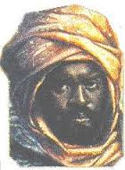
We can retain without great risk of anachronism the detailed description that a Frenchman – probably a surgeon by the name of Girard held in slavery for a few years in Tripoli – gives in 1685 of the sovereign according to the testimonies he collected in this city.
It is in this case the grandson and fourth successor of Idris Alooma, designated under the name of “Mahi-Hagi-Hali”, that is Mai (Hajj) Ali b. Umar b. Idris, who had reigned, according to D. Lange, from 1639 to 1677.
Idris Alooma
“Those who have seen this prince agree that he is nice looking well-built, and of rich stature, but he is black : his ordinary clothes are a robe of white or blue linen, with long sleeves, very fine and untied : he wears the white turban like the Turks, and his face is always more than half covered, because the Bornu people are ashamed (take shame) to show their mouths, and which covers their face from the tip of the nose to the bottom of the chin.”
Chronology of the Bornu Kings from 1512 to 1671. – Extract from manuscript number 12220 (Nouvelles acquisitions. Bibliothèque Nationale, Paris) – Reproduced by le Bulletin de la Société de Géographie de Paris, 1849
It is good to note that, two centuries later, the European travelers who visited Bornu described the robe of the king in identical terms. Such permanence clearly indicates that this is not an occasional outfit, but one of the ritual and traditional insignia of power.
Les Africains, vol. 3, Editions J.A., 1977, p. 53. Translated to English by Dr. Y.,Afrolegends.com
Today, I will be talking about Idris Alooma (also Idris Alaoma, or Idris Alauma), the only Bornu King whose name has survived the test of time. This article is long overdue, as it focuses on the Bornu and Kanem-Bornu empires.
Idris Alooma’s reign belonged to the great Sayfawa or Sefuwa dynasty which ruled the Bornu empire from the 16th and 17th centuries. According to the Diwan al-salatin Bornu, Idris Alaoma was the 54th King of the Sefawadynasty, and ruled the Kanem-Bornu empire located in modern-day Chad, Cameroon and Nigeria. In many works, he is known by his mother’s name, Idris Amsami, i.e. Idris, son of Amsa. The name Aloomais a posthumous qualificative, named after a place, Aloor Alao, where he was buried. He was crowned king at the age of 25-26. According to the Diwan, he ruled from 1564 to 1596. He died during a battle in the Baguirmi where he was mortally wounded; he was later buried in Lake Alo, south of the actual Maiduguri, thus the name Alooma.
Group of Kanem-Bu warriors in the 1800s
Idris was an outstanding statesman, and under his rule, the Kanem-Bornu touched the zenith of its power. He is remembered for his military skills, administrative reforms and Islamic piety. His feats are mainly known through his chroniclerAhmad bin Fartuwa. During his reign, Idris avoided the capital Ngazargamu, preferring to set his palace 5 km away, near the Yo river (Komadugu Yobe), in a place named Gambaru. The walls of the city were red, leading to a new architecture using red bricks characteristic of his reign. To this day, some murals still exist in Gambaru and are over 3m tall. These are vestiges of a flourishing empire. Idris Alooma was known by the Kanuri title of Mai for king.
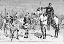
Kanem-Bornu court in the 1700s
His main adversaries were the Hausa to the west, the Tuareg and Toubou to the north, the Bulala to the east, and the Sao who were strongly implanted in the Bornu region (and will be decimated by Alooma’s military campaigns). One epic poem extols his victories in 330 wars and more than 1,000 battles. His innovations included the employment of fixed military camps with walls, permanent sieges and scorched earth tactics where soldiers burned everything in their path, armored horses and riders as well as the use of Berber camels, Kotoko boatmen, and iron-helmeted musketeers trained by Ottoman military advisers. His active diplomacy featured relations with Tripoli, Egypt, and the Ottoman Empire, which sent a 200-memberambassadorial party across the desert to Alooma’s court at Ngazargamu. Alooma also signed what was probably the first written treaty or ceasefire in Chadian history.
Alooma introduced a number of legal and administrative reforms based on his religious beliefs and Islamic law. He sponsored the construction of numerous mosques and made a pilgrimage to Mecca, where he arranged for the establishment of a hostel to be used by pilgrims from his empire. As with other dynamic politicians, Alooma’s reformist goals led him to seek loyal and competent advisers and allies, and he frequently relied on eunuchs and slaves who had been educated in noble homes. Alooma regularly sought advice from a council composed of heads of the most important clans. He required major political figures to live at the court, and he reinforced political alliances through appropriate marriages (Alooma himself was the son of a Kanuri father and a Bulala mother).
Map of the Kanem and Kanem-Bornu empires
Kanem-Bornu under Alooma was strong and wealthy. Government revenue came from tribute (or booty if the recalcitrant people had to be conquered) and duties on and participation in trade. His kingdom was central to one of the most convenient routes across the Sahara desert. Many products were sent north, including natron (sodium carbonate), cotton, kola nuts, ivory, ostrich feathers, perfume, wax, and hides, but the most profitable trade was in slaves. Imports included salt, horses, silk, glass, muskets, and copper.
Alooma took a keen interest in trade and other economic matters. He is credited with having cleared the roads, designed better boats for Lake Chad, introduced standard units of measure for grain, and moving farmers into new lands. In addition, he improved the ease and security of transit through the empire with the goal of making it so safe that “a lone woman clad in gold might walk with none to fear but God.” To learn more, check out the books: History of the first twelve years of the reign of Mai Idris Alooma of Bornu (1571-1533) by his Imam: Ahmed ibn Fartua; together with the “Diwan of the sultans of Bornu” and “Girgam” of the Magumi; and The Africans, ed. J.A. Tome 3, 1977.
When the Zaghawa (people of Kanem) arrived in the area around Lake Chad, they found independent walled-cities states from the Sao civilization, a civilization which had flourished around the 6th century, with its center around the Chari river, south of Lake Chad. The Zaghawa adopted some of the Sao customs, but fight among the two lasted from the 7th century until the 16th. The conquest of Kanem by the Zaghawa was done under the Duguwa dynasty which was started by King Sef (also known as Saif… some people eager to change African history state that the Zaghawa were from Yemen… but we all know that they were local people) about 700 CE. The dynasty, Sayfawa or Sefuwa, is named for King Dugu, one of Sef’s sons, who was ruling about 785 CE. Abandoning their nomadic lifestyle, the Zaghawa established a capital at N’Jimi (meaning “south” — the location of this town is still unknown, but it is believed to be around Lake Fitri). Under the rule of Dugu, Kanem expanded to become an empire. The Zaghawa kings, called maï, were regarded as divine and belonged to a ruling establishment known as the Magumi. They were recognized for a great amount of horses. Kanem’s expansion peaked during the reign of MaïDunama Dabbalemi (ca. 1221-59) and extended northward into the Fezzan region (Libya), westward into Kano (Nigeria), eastward to Ouaddaï (or Wadai), and southward into the Adamawa grasslands (Cameroon). They converted to islam around the 11th century CE.
Group of Kanem-Bu warriors in the 1800s
By the end of the 14th century, internal struggles and external attacks had torn Kanem apart. Between 1376 and 1400, six Maïs reigned, but were killed by foreign invaders. Finally, around 1396 the Bulala invaders forced the once strong Sayfawa dynasty to abandon Njimi and move to Bornu on the western edge of Lake Chad. Around 1472, Maï Ali Dunamami fortified the Bornu state, and established the capital at Ngazargamu, which had more fertile lands. Over time the inter-marriage between the Kanembu and the Borno people created a new people, the Kanembu, and a language called Kanuri.
The Kanem-Bornu empire peaked during the reign of Maï Idris Alooma (ca. 1571 – 1603) who is remembered for his great military and diplomatic skills. His main adversaries were the Hausa to the west, the Tuareg and Toubou to the north, and the Bulala to the east. One epic poem tells of his victories in 330 wars, and over 1,000 battles. He was a true military genius, and some of his innovations included the use of fixed military camps (with walls), permanent sieges, and “scorched earth” tactics, armored horses and riders, the use of Berber camels, of skilled Kotoko boatmen, and of iron-helmeted musketeers trained by Turkish military advisers. He had very strong diplomatic ties with Tripoli, Egypt, and the Ottoman empire, which at some point sent a 200-member ambassadorial party across the desert to Alooma’s court in Ngazargamu. The state revenues came from tribute from vassal states, trans-saharan trade route, and slave trade. Many products such as cotton, natron (sodium carbonate), kola nuts, ivory, ostrich feathers, perfume, was, and hides were exported north via the Sahara desert.
Map of the Kanem and Kanem-Bornu empires
By the end of the 17th century, the empire started declining, and by the 18th century, it only extended westward into the land of the Hausa. By the early 19th century, the declining empire could not sustain the advance from the fulani warriors of Usman Dan Fodio who proclaimed the jihad war against the non-muslims.
To learn more about the Kanem-Bornu empire, check out: Jamtan.com, Daily Kos- Ancient Africa, BlackPast.org, The empire by the lake. Don’t forget to check out the book “Kanem-Borno: One Thousand Years of Splendor (Kingdoms of Africa)” by Philip Koslow. Back in those days, Lake Chad covered an area of about 10,000 m2… today it has sadly shrunk down to 1,300 m2, and is still shrinking! I could not find a really good map of the Kanem or Kanem-Bornu empire, so I used Google maps and known maps from history books to make my own with some of the boundaries cited earlier. I have overlaid the Kanem and the Kanem-Bornu empires on the same map to give a better idea. Enjoy!