Why the name: Antananarivo?

Madagascar
Madagascar

Ever wondered about the meaning of the name Antananarivo, the capital of Madagascar? Like: why does the ‘na‘ repeat itself twice (nana)? or whether this ‘nana‘ could mean mother or father or grandmother or grandfather as in many African languages, or ‘girl‘ in French? or could the ‘rivo‘ have something to do with river? or have you simply wondered why such a long name for a capital city?

Flag of Madagascar
Flag of Madagascar

Well, I have often wondered about Antananarivo because of the way its name falls from my mouth as if I was in a hurry, and then being rushed to say it quickly so as not to stumble. I have also wondered about its name, because it reminds me of the beauty of its country, Madagascar, the big island. Moreover, numerous neighborhoods in Cameroon have been renamed after the country because of its beauty and also I imagine, by respect for its people’s struggle for independence which was similar for the people of Cameroon.

Antananarivo in 1905

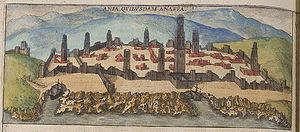
The name Antananarivo means “the City of Thousand” with an meaning ‘to‘ or ‘at‘, tanan meaning ‘city‘, and (a)rivo meaning ‘thousand‘. Some think the ‘thousand’ is in reference to ‘thousand hills‘ or ‘thousand soldiers‘ in reference to the important royal Merina guard. In reality, Antananarivo was the site of a town called Analamanga, meaning ‘Blue Forest‘ in Malagasy. Analamanga was founded by the Vazimba people, the island’s first occupants. When King Andrianjaka of the Merina people moved into the area between 1610 and 1625, he deployed a garrison of 1,000 soldiers to successfully capture the city and guard the site. Declaring it his capital, Andrianjaka built a rova (fortified royal dwelling) that expanded to become the royal palaces of the Kingdom of Imerina. The site maintained its name Analamanga until it was renamed almost fifty years later by King Andriamasinavalona as Antananarivo, “City of the Thousand“, in honor of King Andrianjaka’s soldiers. People of Madagascar affectionately call it “Tana“, the city, and its named was frenchified during colonial time into Tananarive.

Manjakamiadana, the Royal compound built for Queen Ranavalona I

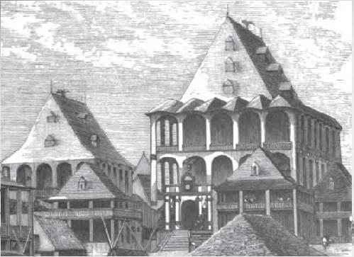
The city was first built as a fortress by the Merina Kings at the beginning of the 17th century, who made it the capital of the united Kingdom of Imerina in 1794. The community grew rapidly under the Merina Kings, and particularly under King Radama I whose control ultimately extended over a major part of the island, leading him to be considered the King of Madagascar by European diplomats, with Antananarivo as the island’s capital. Antananarivo remained the island’s capital after Madagascar was colonized by the French in 1897 , after the French military invaded Antananarivo on September 1894 causing major casualties amongst the Malagasy people, and causing queen Ranavalona III to surrender. Claiming the island as a colony, the French administration retained Antananarivo as its capital and transcribed its name as Tananarive. Antananarivo remained the capital of Madagascar after independence in 1960.

Antananarivo (Wikipedia)
Antananarivo today (Wikipedia)

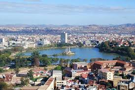
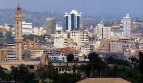
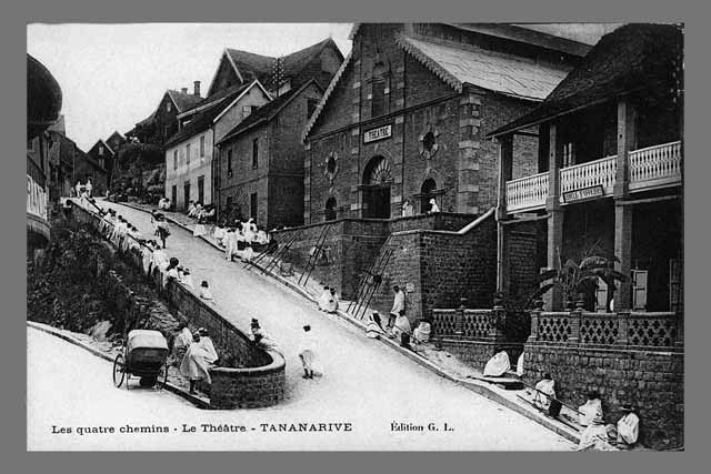
Today, Antananarivo is a vibrant city full of life, culture, and immense history. The city’s skyline is dominated by the rova of Antananarivo, which was destroyed in a 1995 fire but is under reconstruction. The nearby Andafiavaratra Palace was the home of 19th century Prime Minister Rainilaiarivony and currently contains a museum featuring historic artifacts of the Kingdom of Imerina. Downhill from the palaces is Andohalo square, where Merina kings and queens delivered speeches to the public.  Tsimbazaza Zoo displays many of the island’s unique animal species and a complete skeleton of the now-extinct elephant bird. Other historic buildings include the Ambatondrafandrana tribunal where Ranavalona I dispensed judgement, the second residence of Rainilaiarivony with its indigenous medicinal plant garden, the recently renovated Soarano railroad station, four late 19th century memorial churches built to commemorate early Malagasy Christian martyrs, the tomb of Prime Minister Rainiharo, and the early 20th century pavilions of the Analakely market. Enjoy the video below, and if you are ever in Madagascar, please do visit the beautiful Tana, the capital of the great Merina Kings, named to celebrate a thousand courageous soldiers and the beautiful hills of the central highlands.


Why the name: Mogadishu?

Map of Somalia
Map of Somalia

Have you ever wondered what the name of the capital city of Somalia, Mogadishu, meant? Somalia has been in the news in recent decades, particularly after the humiliation the American army received with Operation Restore Hope in 1993 at the hand of the local proclaimed president-to-be Mohamed Farrah Aidid, and also because of pirates roaming its coasts in the 2000s. The movie Black Hawk Down shows part of this operation with the ensuing Battle of Mogadishu, while Captain Phillips focuses on pirates.

The city of Mogadishu is located on the Indian Ocean coast of the Horn of Africa, in the Banaadir administrative region (gobol) in southeastern Somalia. The name Mogadishu is said to come from the Persian word Maq’ad-i-Shah, which means “the seat of the Shah.” This is a reflection of the city’s early Persian influence. Locally, it is spelled Muqdisho. To locals, the city is also known as Xamar.

Engraving of the 13th century Fakr ad-Din Mosque in Mogadishu

So where does the Persian influence stem from in a city on the horn of Africa? Well, for starters, the city was founded in the 10th century by Arab traders. However, 2500 years old relics and pictographs were found on rocks in northern Somalia attesting to the area’s ancient occupation. Tradition and old records assert that southern Somalia, including the Mogadishu area, was inhabited in early historic times by hunter-gatherers of Khoisan descent who were later either driven out of the region, or assimilated by other migrants in the area.

Mogadishan medieval ship

In 1331, the Moroccan explorer Ibn Battuta visited the city when it was at its zenith. He described Mogadishu as “an exceedingly large citywith many rich merchants, which was famous for the high quality fabric that it exported to destinations including Egypt. Batutta added that the city was ruled by a Somali Sultan, Abu Bakr ibn Sayx ‘Umar, who was originally from Berbera in northern Somalia and spoke both Somali (referred to by Battuta as Mogadishan, the Benadir dialect of Somali) and Arabic with equal fluency. The Sultan also had a retinue of wazirs (ministers), legal experts, commanders, royal eunuchs, and other officials at his service.

There appears to have been a strong Persian presence in both Mogadishu and Zeila for a time. A Shi’a influence can still be seen in some areas, as in the southern Somalia veneration of Fatimah, the Prophet Muhammad‘s daughter. Moreover, in the olden days, the city’s textiles were forwarded far and wide throughout the interior of the continent, as well as to the Arabian peninsula and as far as the Persian coast.

Zheng He
Zheng He, Chinese explorer

The Chinese navigator Zheng He visited the region with his expedition from 1413 to 1415.  From the 13th to the 15th centuries, Mogadishu was an important city of the Ajuran Sultanate. The city was governed by the Muzzaffar dynasty. Mogadishu is one of the rare cities on the East coast of Africa which was never conquered by the Portuguese whose attempts to occupy the city failed in the 16th century. However, the Muzzaffar dynasty lost control of the city to the Hawiye Somali when the Ajuran sultanate was defeated in the 17th century.

By 1892, Mogadishu was under the joint control of the Somali Sultanate of the Geledi and the Omani Sultanate of Zanzibar. The Geledi Sultans were at the height of their power. They dominated the southern ivory trade, and also held sway over the Jubba and Shebelle valleys in the hinterland.

In 1905, Italy made Mogadishu the capital of the newly established Italian Somaliland. The Italians subsequently referred to the city as Mogadiscio. After World War I, the surrounding territory came under Italian control with some resistance. Thousands of Italians settled in Mogadishu and founded small manufacturing companies. They also developed some agricultural areas in the south near the capital, such as Janale and the Villaggio duca degli Abruzzi (present-day Jowhar). In the 1930s, new buildings and avenues were built. A 114 km (71 mi) narrow-gauge railway was laid from Mogadishu to Jowhar. An asphalted road, the Strada Imperiale, was also constructed and intended to link Mogadishu to Addis Ababa.

Mogadishu (downtown) in 1936, Arba'a Rukun Mosque to the centre right
Mogadishu (downtown) in 1936, Arba’a Rukun Mosque to the centre right

British Somaliland became independent on 26 June 1960 as the State of Somaliland, and the Trust Territory of Somalia (the former Italian Somaliland) followed suit five days later. On 1 July 1960, the two territories united to form the Somali Republic, with Mogadishu serving as the nation’s capital.

In 1990, Mogadishu fell under the control of rebels who forced President Mohamed Siad Barre into exile. The rebels formed rival factions each recognizing different presidents, and civil war broke out. In 1992, the United Nations sent armed forces led by American forces. After deadly combats, the American forces were defeated and forced to run away by Aidid‘s troops.

Sandy beach in Mogadishu

Today, the amazing sandy beaches of Mogadishu with its vibrant coral reefs are prime land for tourist resorts. Since the city’s pacification on 2011, the city is slowly rebuilding, and establishing international trades with other cities and countries. Mogadishu traditionally served as a commercial and financial centre. Mogadishu’s economy has grown rapidly since then. The Port of Mogadishu is the official seaport of Mogadishu, and the largest harbour in the country. Please enjoy this vibrant, reviving, and historical city. Do check out Somaliagenda.com for amazing pictures of Mogadishu and its people.


Why the Name: Oran?

Oran
Oran

Oran, “the radiant,” is the name often given to the second most populous city of Algeria. In the past, I used to think that the name Oran had something to do with orient, the east. So from “radiant” to “orient”, which is true? or is there another meaning to the name of this beautiful Algerian city?

The name Oran comes from Wahran, which comes from the Berber word Uharu for Lion. One of the known forms of the word, Wadaharan, could come from “Wad + Aharan“, or “the river of Lions.”

Oran, from City Hall steps, 1894 (Library of Congress)

Several legends link the name of the city to lions. Legend says that in 900 AD, there were still lions in the area; in the mystic legend, a lion had appeared on the grave of the saint patron Sidi El Hourari. The most common tradition traces the name of the city to the dream of the son of the Vizier of Cordoba, who was running away by sea from the tyranny of his father who opposed his marriage to the woman he loved. On his way, a storm arose, and he had a vision of two lion cubs, and a shipwreck on La Plage des Andalouses in Oran.

Either way, the last two lions were hunted on a mountain near Oran referred to as “mountain of lions,” also known as Djebel Kar, the mountain of rubbles. The French name, Mountain of lions, indicates that there were still lions living in that area at the beginning of the 19th century. Two giant lion statues stand in front of Oran’s city hall, symbolizing the city.

Oran, today
Oran, today

During the Roman empire, the region of Oran was a small settlement called Unica Colonia, which disappeared after the Arab conquest of the Maghreb. Founded in 902 by Moorish Andalusi traders, Oran saw a succession of Arab-Berber dynasties. It was captured by the Spanish under Cardinal Cisneros in 1509, Spanish sovereignty lasted until 1708, when the city was conquered by the Ottomans. Spain recaptured the city in 1732. However, its value as a trading post had decreased greatly, so King Charles IV sold the city to the Turks in 1792 (some sources say that it was conquered, rather than sold to the Bey Mohamed El Kebir). Ottoman rule lasted until 1831, when it fell to the French. During French colonization, Oran saw a rapid development and became Algeria‘s second city.

Flag of Algeria
Flag of Algeria

After independence in 1962, Oran remained the capital of the West of the country, and its principal financial, commercial, and industrial center. It is today one of the most important cities of the Maghreb. It is a port city on the Mediterranean sea, located in the northwest of Algeria, 432 km from the capital Algiers, and is the capital of the Oran Province in the gulf of Oran. Oran is a major port and a commercial centre, with three major universities. It is also the birthplace of the Raï, the Algerian folk music made popular by singers such as Cheb Khaled, Cheb Mami, Raïna Raï, and others.

Please enjoy this video of Oran, the city of Lions, Oran the radiant, the city of Raï.


Why the name: Dakar?

Map of Senegal
Map of Senegal

After talking about one of the great queens of Senegal, Queen Ndate Yalla Mbodj, it made total sense to explore the meaning of the capital and largest city of Senegal: Dakar. Is the name a local Wolof name? or does it have a French origin? Is the name’s meaning linked to Dakar’s strong fishing tradition or something else?

Map of Dakar in 1850

The name Dakar could be the French version of Ndakaarou (Ndakaaru), local name whose etymology still remains uncertain. It could be derived from the wolof deuk raw meaning “whoever settles here will be in peace,” or dekk-raw from dekk (country), and raw (to escape) because of the afflux of populations from the Cayor and Baol regions after the Lebous settled there. It could also arise from the wolof dakhar, the name for the tamarind tree: it is said that upon arrival in the area, the Lebou people were impressed by the huge numbers of Tamarind trees they saw, and thus named the area after it, dakhar. However, some historians think that the area was named after a French marine officer Accar or d’Accard, who lived there at the end of the 17th century, and was mentioned on maps of that era. The name Dakar first appeared on a 1750 map of the Cap-Vert Peninsula, drawn by French botanist Michel Adanson.

Map of Dakar in 1888

The Cap-Vert peninsula was settled, no later than the 15th century, by the Lebou people, an aquacultural ethnic group related to the neighboring Wolof and Serer. The original villages: Ouakam, Ngor, Yoff and Hann, still constitute distinctively Lebou neighborhoods of the city today. In 1444, the Portuguese reached the Bay of Dakar, initially as slave-raiders, but were repulsed by the natives on the shores. Peaceful contact was finally opened in 1456 by Diogo Gomes, and the bay was subsequently referred to as the “Angra de Bezeguiche” (after the name of the local ruler). Due to its key location, the bay of “Bezeguiche” would eventually serve as a critical stop for the Portuguese India Armadas of the early 16th century.

Hotel de Ville of Dakar, 1920

The Portuguese eventually founded a settlement on the island of Gorée (then known as the island of Bezeguiche or Palma), which by 1536 they began to use as a base for the export of slaves. The mainland of Cap-Vert, however, was under control of the Jolof Empire, as part of the western province of Cayor which seceded from Jolof in its own right in 1549. A new Lebou village, called Ndakaaru, was established directly across from Gorée in the 17th century to service the European trading factory with food and drinking water.

Public well in Dakar in 1899

The city of Dakar is a commune, one of the 67 communes of Senegal. The commune of Dakar was created by the French colonial administration on June 17, 1887 by detaching it from the commune of Gorée. The commune of Dakar is also a department, one of the 34 departments of Senegal; this is quite similar to Paris, which is both a commune and a department. Dakar was also the capital of the short-lived Mali Federation from 1959 to 1960, before becoming the capital of independent Senegal in 1960. The poet, philosopher and first President of Senegal, Léopold Sédar Senghor, tried to transform Dakar into the “Sub-Saharan African Athens” (l’Athènes de l’Afrique subsaharienne).

The African Renaissance Monument with a view of Dakar and the ocean (Carrapide.com)

In its colonial heyday Dakar was one of the major cities of the French Empire, comparable to Hanoi or Beirut. French trading firms established branch offices there and industrial investments (mills, breweries, refineries, canneries) were attracted by its port and rail facilities. Today, Dakar is a major financial center, home to national and regional banks, and numerous international organizations, NGOs and international research centers. Beginning in 1978 and until 2007, Dakar was frequently the ending point of the famous Dakar Rally. It is also home to the IFAN Museum of West African culture, and the tallest sculpture in Africa, the African Renaissance Monument.

Dakar is a vibrant and cosmopolitan city. Located on the shores of the Atlantic Ocean, its numerous sandy beaches and the warmth of its people make it a rare pearl. Enjoy the video below, and if you get a chance, do visit this “Athens of Sub-Saharan Africa”, and do not forget to taste the amazing fish, and world-renowned Senegalese cuisine, and feel the spirit of the teranga (hospitality).


Why the Name: N’Djamena?

Map of Chad (Source: Lonely Planet)
Map of Chad

N’Djamena … Oh Oh Oh Oh N’Djamena… N’Djamena … J’irai un jour à N’Djamena en passant par le Lac Tchad” (I will one day go to N’Djamena, via Lake Chad) says Cameroonian singer Andre Marie Tala with his great song “N’Djamena”. Have you ever wondered what the name of the capital of Chad might mean? Is it a Ngambaye’s name? Daza? Hausa? Arab? Sara? or Kotoko? or does it come from the ancient Kanem-Bornu, or Bornu Empires that flourished in the region centuries ago? or is it simply a mix of Arabic with some local language?

Flag of Chad
Flag of Chad

In reality, N’Djamena means “the city where one rests” (la ville où l’on se repose), or “the city where one finds rest.” Thinking about it, it is somewhat similar in meaning to that of Tunis, the capital of Tunisia, whose name means “to spend the night,” or “to lie down,” or “the area where one spends the night.”

Place de la Nation, N'Djamena
Place de la Nation, N’Djamena

The city was not always called N’Djamena. In fact before 1973, it was called Fort Lamy, after a French army officer who had been killed in the Battle of Kousséri on May 29, 1900,  Amédée-François Lamy. It was a major trading city and became the capital of the region and nation. It is located on the Chari River, near the confluence with the Logone River, and directly faces the Cameroonian city of Kousséri, to which it is connected by a bridge, just like Brazzaville and Kinshasa, the capital cities of the two Congos. N’Djamena is a regional market for livestock, salt, dates, and grains. Meat, fish, and cotton processing are the main industries, and the city is the economic capital of the country as well as its political capital. It is Chad’s largest and most populous city.

On April 6, 1973, President François Tombalbaye changed the name of the city from Fort Lamy to N’Djamena. The name N’Djamena was taken from the Arab name of a nearby village, Nijamina or Am Djamena, meaning “place of rest“. Enjoy the great song by André Marie Tala, and like he says “I will one day go to N’Djamena… to discover its beautiful landscape.” Enjoy this great place of rest!


Why the name: Zimbabwe?

Zimbabwe2One of my very first articles on this blog was on Great Zimbabwe, the capital city of the Kingdom of Zimbabwe, a kingdom which flourished from approximately 1220 to about 1420 in Southern Africa. The modern-day country of Zimbabwe is named after this great kingdom, and it is only befitting that we explore together the origin of its name. Why would a country which was named Southern Rhodesia change its name to Zimbabwe? Why bother changing names?

Flag of Zimbabwe
Flag of Zimbabwe

Well, for starters, I find it a bit sad for a country to only be known as ‘Southern something’ without no real name of its own… I know, … things happen (like countries splitting apart). Secondly, Rhodesia was named after Cecil Rhodes, the British man who committed the greatest atrocities in Southern Africa, while establishing British rule over the different African countries in the late 19th century. Therefore, once the people of Southern Rhodesia became independent from British rule, it was only normal to claim a name that was theirs, and not the name of some foreign oppressor who committed the worst atrocities in their country. It’s like seeing yourself through someone else’s lens; you only become free once you can look through your own lens, and appreciate and value yourself.

Great Zimbabwe ruins

Thus the name Zimbabwe was chosen. The name “Zimbabwe” is a Shona term for Great Zimbabwe, an ancient ruined city in the country’s south-east whose remains are now a protected site, in the modern-day province of Masvingo. There are two theories on the origin of the word. The first theory holds that the word is derived from dzimbadzamabwe, translated from the Karanga dialect of Shona as “large houses of stone” (dzimba = plural of imba, “house“; mabwe = plural of bwe, “stone“).  The second theory claims that “Zimbabwe” is a contracted form of dzimba-hwe which means “venerated houses” in the Zezuru dialect of Shona, and is usually applied to chiefs’ houses or graves. In your opinion, which of these two theories is closer to the truth?

A Conical tower
A Conical tower

Zimbabwe was formerly known as Southern Rhodesia (1898), Rhodesia (1965), and Zimbabwe Rhodesia (1979). The first recorded use of the name “Zimbabwe” as a term of national reference was in 1960, when it was coined by the black nationalist Michael Mawema, whose Zimbabwe National Party became the first to officially use the name in 1961. According to Mawema, black nationalists held a meeting in 1960 to choose an alternative name for the country, and the names Machobana and Monomotapa were proposed before his suggestion, Zimbabwe, prevailed. I am so glad the name Zimbabwe was chosen. Enjoy this video about Zimbabwe, the country which held the great civilization of stones. I will talk about the different great kingdoms and civilizations that flourished in the area in later posts.

Why the name: Kampala?

Kasubi Tombs (aboutuganda.com)

In college, I was always fascinated by my Ugandan friend’s account of the Kabaka of Buganda, of his palace located in Kampala, and of the rich tradition of the Buganda Kingdom. I started wondering what the capital of Uganda‘s name meant. After all, its name is beautiful, Kampala, resonant with grace, peace, and radiance. I was pleasantly surprised to find out that Kampala indeed was named after the graceful impala antelope.

Impala antelope
Impala antelope

Yes, indeed, before the arrival of the British in the area, the Kabaka (King) of Buganda had chosen the area as his favorite hunting ground because of its numerous rolling hills, and wetlands. This area was also home to several species of antelopes, and particularly the impala.

When the British arrived in the region, they renamed it ‘Hills of the Impala’. The translation in Luganda, the language of the Buganda people, yielded Kasozi Ka Empala (Kasozi Ka meaning hill of), and Empala being the plural for impala. To the listening ear, Ka Empala sounded like one word Ka’Mpala. When the king would go hunting, the Buganda people would say Kabaka a’genze e Ka’mpala (the Kabaka has gone to Ka’mpala). Thus was born the name of the city Kampala.

Map of Uganda
Map of Uganda

Kampala then grew to be the capital of the Buganda Kingdom. A lot of cultural heritage buildings can still be found there, such as the Kasubi Tombs, built in 1881, to house the tombs of previous Kabakas. The Kasubi Tombs have been recognized as UNESCO World Heritage Site. Kampala is also home to Lubiri Palace (the royal house of the Kabaka), the Buganda parliament, and the Buganda court of justice.

In 1962, Kampala replaced Entebbe as the capital of Uganda. A big part of the city was destroyed during the war with Tanzania in 1978, which culminated with the removal of Idi Amin Dada from power in 1979, and the civil war. The city has since then been rebuilt.

Kampala is surrounded by hills to the north, papyrus wetlands, and Lake Victoria to the south. Like many cities around the world (including Yaoundé), Kampala also claims to have been built on 7 hills, although it is not quite true. The 7 historical hills of Kampala are:

Lubiri Palace seen at the top of the hill, 1875

Kasubi Hill: the first hill in historical importance, and home to the  Kasubi Tombs, burial ground of the previous Kabakas of Buganda;

Mengo Hill: where Lubiri Palace is located, as well as the Buganda court of justice, and the Lukiiko, Buganda parliament;

Kibuli Hill: home to the Kibuli Mosque. Interestingly enough, Islam was brought to Uganda before Christianity by Muslim slave traders;

Namirembe Hill: home to the Namirembe Anglican Cathedral. The first Christians in the area were protestants;

Lubaga Hill: site of the Rubaga Catholic Cathedral, and the ‘white fathers’ neighborhood;

Nsambya Hill: home to the Nsambya Hospital;

Kampala Hill: the hill of the impala which hosts the ruins of Fort Lugard. This hill gave its name to the city.

Kampala today (enjoyuganda.info)

With time, the city spread to Nakasero Hill where the administrative centre and the wealthiest residential area are, Tank Hill, where the water storage tanks that supply the city are located. Mulago Hill is the site of Mulago Hospital, the largest hospital in Uganda. The city is now rapidly expanding to include Makindye Hill and Konge Hill.  Kololo Hill to the east of Nakasero hill, is the highest hill in the city, at 1,300 metres above sea level, and is home to the Uganda Museum. As one can see, Kampala is truly a city of hills. Maybe it should be nicknamed the city with the thousand hills or hundred hills. Today, Kampala is a vibrant city, full of history, and modernism. Enjoy this video of Kampala.


Why the Name: Casablanca?

'Casablanca', 1942 movie starring Humphrey Bogart and Ingrid Bergman
‘Casablanca’, the 1942 movie

What comes to mind when I say Casablanca? If your thoughts went to the 1942 Hollywood romantic movie ‘Casablanca‘ which starred Humphrey Bogart and Ingrid Bergman, you are not the only one; even Google makes the same mistake. However, I will be talking about the city that inspired the movie, the Moroccan city of Casablanca.

Casablanca in 1572, still called Anfa on this painting

Have you ever wondered where the name Casablanca came from? Why would a Moroccan city not have an Arabic name, but a Spanish name? Why is there the color white in its name? Were all the houses painted in white when its name was chosen? After all, a literal translation of Casablanca is ‘Casa‘ and ‘Blanca‘ or ‘white house’ in Spanish. Was Casablanca a Spanish conquest? In reality, the modern name of the city comes from the Portuguese ‘Casabranca‘ or ‘white house’ which turned into Casablanca when the Portuguese kingdom was integrated into the Spanish kingdom.

Streets of Casablanca in 1930

The real name of the city was Anfa, founded as part of the Berber Kingdom of Barghawata in 744 AD. It is believed to have been one of the most prosperous cities on the Atlantic coast because of its fertile land. After the Portuguese wiped out the entire city in 1468, they used the ruins of Anfa to build a military fortress in 1515, and later renamed the city Casabranca. I wonder how many African cities were wiped out that way by Europeans; this is so reminiscent of the majestic Benin City which was burnt to the grounds by British soldiers in 1897.

The port of Casablanca in 1915

Between 1580 and 1640, the Crown of Portugal was integrated into the Crown of Spain, and the area was renamed Casablanca, even though it was still under an autonomous Portuguese administration. As Portugal broke ties with Spain in 1640, Casablanca came under full Portuguese control again. The Europeans abandoned the area completely in 1755 following an earthquake which destroyed most of the town, probably leaving the locals to fend for themselves.

Casablanca in 2012
Casablanca in 2012

The town was finally reconstructed by Sultan Mohammed ben Abdallah (1756–1790), the grandson of Moulay Ismail, with the help of Spaniards from the nearby emporium. The town was called الدار البيضاء ad-Dār al-Bayḍāʼ, the Arabic translation of the Spanish Casa Blanca, meaning “white house”. The city came under French occupation at the beginning of the 20th century, as Morocco became a French protectorate.

Since Morocco gained independence from France in 1956, the city has become the economic and business center of the country. Located in the Chawiya plain, its very fertile lands have made it the breadbasket of Morocco. One of its most important exports is phosphate. Among other industries, there is also a big fishing and fish canning industry: who has not heard of the delicious Moroccan Sardines?

Hassan II Mosque with its world tallest Minaret

Apart from being the biggest city in the Maghreb, and being so modern with a twist of Hispano-Mauresque, and French architectures, Casablanca is also home to the Hassan II Mosque, with the world’s tallest Minaret. Locals affectionately call it ‘Casa‘, and it is a beautiful city to visit, with a very modern architecture. Enjoy the video below.

Why the name: Lagos?

Flag and map of Nigeria

Today, I will talk about the most populous city in Africa. If you thought Lagos, that vibrant and chaotic city in Nigeria, you guessed right. Growing up, I always thought the name Lagos was some anglicized version of a native name given by a local Yoruba tribe. Now in retrospective, I see how far my guess was from the truth.

It turns out that Lagos actually means ‘Lakes’ in Portuguese. There are different explanations for the name itself: according to some historians, Lagos was the name given by the Portuguese explorer Rui de Sequeira when he visited the area in 1472, naming the area around the city, Lago de Curamo, or Lake of Healing. Other historians think that the area was named after the city of Lagos in Portugal, a maritime town which had been the main center of Portuguese expeditions down the African coast, and whose name was derived from the latin word Lacobriga.

Lagos, Nigeria (Wikipedia)

In reality, the area that is known today as Lagos was originally occupied by the Awori tribe, a subgroup of the Yoruba people. Under the leadership of the Oloye Olofin, the Awori moved to an island called Iddo, and then later to the larger Lagos Island. In the 15th century, the Awori settlement was conquered by the Bini people of the Benin Kingdom, and the island became known as ‘Eko‘ under Oba Orhogba, the Oba of Benin at the time. To this day, Yoruba people still refer to Lagos as Eko.  Lagos became a major center for slave trade during the 18th century.

Map of Lagos
Map of Lagos

The site of the city of Lagos is made up of a group of islands separated by creeks in a lagoon (Lagos Lagoon) sheltered from the Atlantic Ocean by barrier islands and long sand spits, all located in the Bight of Benin, a part of the Gulf of Guinea.

Annexed by the British in 1861, the area became known as the British Lagos Colony. The remainder of modern-day Nigeria was seized by the British in 1887, and became a British Colony and Protectorate of Nigeria in 1914, whose capital was Lagos. Lagos was the capital of the British Colony of Nigeria, until after independence in 1960, when it became the capital of the Federal Republic of Nigeria. It remained its capital until 1991, when the capital was moved to the purposely-built city of Abuja (it is a planned city just like Brasilia, and was mainly built in the 1980s). On 14 November 1991, the presidency and other federal government functions were relocated to the capital city of Abuja. During the 20th century, Lagos’ population increased twenty-fold and urbanization has kept expanding into the continent. It is in part due to this uncontrollable sprawling that the government decided to move the capital to Abuja.

Lagos, Independence Square, 1960 (Source: Lamudi.com.ng)
Lagos, Independence Fountain, Tinubu Square, 1960 (Source: Lamudi.com.ng)

The port of Lagos is Nigeria’s leading port, and one of Africa’s busiest and largest. Lagos has one of the largest and most extensive road networks in West Africa, and is renowned throughout Africa for its seemingly insurmountable traffic congestions. It is also known as the birthplace of the Afrobeat, a musical movement which was the brainchild of the great Fela Kuti. Lagos is also the home of Nollywood, Nigeria’s film industry (named in reference to Hollywood and Bollywood). In all, Lagos is mostly a business-oriented and fast paced city; it is indeed the economic capital of Nigeria, and its lungs. I guess one could say, without Lagos, there is no Nigeria.

National Geographic just published an article on Lagos. Do also read the article by the Financial Times, Lessons from Lagos. Enjoy the video below.

In your opinion, which one of the two versions for the origin of the name Lagos is the most accurate?

Why the Name: Luanda?

Map of Angola
Map of Angola

I often wondered where the name of Luanda, the capital and largest city of Angola, came from. After the African Cup of Nations was organized in Angola in 2010, I had started thinking about it: was it a Kimbundu word, or Umbundu, or Kikongo? or did it have Portuguese roots?

Map of Luanda in the 1700s

Well, it turns out that, on 25 January 1576, Portuguese explorer Paulo Dias de Novais founded Luanda under the name of “São Paulo da Assumpção de Loanda”.  When he arrived on the Ilha do Cabo (Cape Island), he found an indigenous population, the Axi-Iwanda people, a subgroup of the Ambundu people which were tributary to the Kongo Empire.  The island was an important location to collect zimbo, shells used as currency by the Kongo king before the arrival of Portuguese in the area. Novais established a Portuguese settlement of about 700 people: 350 soldiers, missionaries, merchants, and officials, and families, to first gain control of the currency, before establishing himself on the mainland, opposite the island. They started to use the name of the Axi-Iwanda inhabitants as a name for the island and the town, spelling it first “Loanda, then “Luanda“.

Queen Nzingha sitting on the back of her servant
Queen Nzingha sitting on the back of her servant, during her audience with the Portuguese governor in Luanda

In 1618, the Portuguese built the fortress of Fortaleza São Pedro da Barra, and they subsequently built two more in 1634 and 1765: Fortaleza de São Miguel and Forte de São Francisco do Penedo , respectively. Of these, the Fortaleza de São Miguel is the best preserved. In 1622, Queen Nzingha had an audience with the Portuguese governor in Luanda (this was before she became queen). The city of Luanda has been the administrative center of the colony of Angola since 1627, except from 1641 to 1648 when it was under the control of the Dutch Company of West Indies.  From 1550 to 1836, Luanda was an important center for slave trade to Brazil. When Angola became an actual Portuguese colony, the city was divided between white neighborhoods and indigenous ones, as was tradition in almost all European colonies. The white colonialists lived in huge villas with servants, while the local populations lived in huts. The majority of the local population present in Luanda were Ambundu and Bakongo.  The colonial army would constantly guard the entrance to the European neighborhoods.

View of Luanda in 1883

After the slave trade was abolished in 1836, Angola’s ports were then opened to foreign shipping in 1844. By 1850, Luanda was one of the greatest and most developed Portuguese cities in the vast Portuguese Empire outside Continental Portugal, full of trading companies, exporting palm and peanut oil, wax, copal, timber, ivory, cotton, coffee, and cocoa, among many other products. Maize, tobacco, dried meat, and cassava flour were also produced locally. In 1889, Governor Brito Capelo inaugurated an aqueduct which supplied the city with water, laying the foundation for major growth. After the establishment of the republican regime in Portugal in 1910, colonialism entered a new phase. The new Portuguese government started building schools in Angola. The first high school, Liceu Central de Luanda, was created in 1919. During the authoritarian Estado Novo years, Luanda was also used as a penitentiary colony, used to host convicted criminals.

Agostinho Neto
Agostinho Neto, first president of Angola

A few months after independence from Portugal in 1975, with Agostinho Neto becoming Angola’s first president, civil war broke in the country when the city of Luanda was attacked by the FNLA forces supported by Portuguese mercenaries. This assault was pushed back by the governmental army (MPLA) supported by Cubans in the battle of Kifangondo. Throughout the years, the civil war forced many people across the country to seek refuge in Luanda. After the death of  Jonas Savimbi, UNITA‘s leader in 2002, a ceasefire was reached, and Angola finally arose from over 25 years of civil war.

Flag of Angola
Flag of Angola

Today, Luanda is the siege of the country’s principal companies: Angola Telecom, Unitel, Endiama, Sonangol, Linhas Aéreas de Angola, and Odebrecht Angola (Brazilian company). Back in 1972, it was already called the “Paris of Africa.” Manufacturing is big in the city. Petroleum found in nearby off-shore deposits is refined in the city. Luanda has an excellent natural harbor. The city also has a thriving building industry, an effect of the nationwide economic boom experienced since 2002, when political stability returned with the end of the civil war. Large investments, along with strong economic growth, have made Luanda one of the fastest growing cities of Africa, and of the world. Surrounded by beautiful beaches, and rich through its culture, Luanda is truly an African pearl. Please enjoy this video of one of the jewels of Africa, Luanda.