Young girl attending the Timkat Festival (Carlos de Souza, AFP)Timkat festival
Today, I would like to talk about the Timkat Festival, which is an Ethiopian celebration of Epiphany. It is usually celebrated on 19 January or on 20 January on leap years (which is the 10th day of the Terr – Ethiopian calendar). This festival celebrates the baptism of Jesus Christ on the Jordan river by John the Baptist. It is particularly praised for its reenactment of the baptism. Pilgrims come from around the country to celebrate the Epiphany, which lasts three (3) days. During the ceremonies of Timkat, the Tabot, a model of the Ark of the Covenant, is reverently wrapped in rich cloth and borne in procession on the head of the most senior priest to a place near the river, where a special tent will be erected for it. The Tabot represents the manifestation of Jesus as the Messiah when he came to the Jordan river for baptism; this holy relic is also said to hold the ten commandments as handed down to Moses by God on Mount Sinai. The Divine Liturgy is celebrated near a stream or pool early in the morning (around 2 a.m.). Then the nearby body of water is blessed towards dawn and sprinkled on the participants, some of whom enter the water and immerse themselves, symbolically renewing their baptismal vows. It is a feast of celebration, and processional crosses of varying size and elaboration as well as various Ethiopian artifacts can be seen on the occasion. Participants wear the traditional shamma, which is a thin, white cotton wrap worn like a toga and as headdress. The best place to attend the event is in Lalibela, Gondar, or Addis Ababa. The actual ark of the Covenant is said to be held in a place in northern Ethiopia, guarded by priests who have sworn never to leave the chapel grounds.
Today, I will tell you about the Battle of Isandlwana, the battle where the mighty Great Britain lost to African warriors… Yes you heard me right: Great Britain lost to Zulu warriors in South Africa on 22 January 1879. The battle of Isandlwana remains the single greatest defeat of the British army at the hands of a native army. This occurred in KwaZulu-Natal, where approximately 22,000Zulu warriors defeated a contingent of approximately 1,350 British and Native troops (notice… the real number for the native forces cannot be found anywhere) in one of the first engagements of the Anglo-Zulu war. The Zulu force was under King Cetshwayo, a nephew of King Shaka Zulu.
Zulu King Cetshwayo, ca 1879
The Battle of Isandlwana is a battle of pride as it reminds us that our ancestors did not quietly accept colonization, and were not easily defeated. They fought, and even defeated the European colonizers, as is the case for Cetshwayo’s forces. The battle was a decisive victory for the Zulus and caused the defeat of the first British invasion of Zululand. For the first time, the British Army suffered its worst defeat against a technologically inferior indigenous force. Isandlwana resulted in the British taking a much more aggressive approach in the Anglo–Zulu War, leading to a heavily reinforced second invasion and the destruction of King Cetshwayo’s hopes of a negotiated peace.
A depiction of the Battle of Isandlwana, taken from the London News
The Zulus were equipped mainly with the traditional assegai (iklwa) iron spears and cow-hide shields. The British and colonial troops were armed with the state-of-the-art Martini-Henry breech-loading rifle and two 7 pounder artillery pieces as well as a rocket battery. He he he… Despite a vast disadvantage in weapons technology, the numerically superior Zulus commanded by inDunas(Princes) Ntshingwayo kaMahole Khoza and Mavumengwana kaNdlela Ntuli ultimately overwhelmed the British, killing over 1,300 troops, including all those out on the forward firing line. The Zulu army wiped six (6) companies of the 24th regiment as well as volunteers from the Natal province and Basotho auxiliaries under Colonel Durnford. The Zulu army suffered around a thousand killed.
Zulu warriors at Isandlwana, 1879
The primary reason for the Zulu victory is that the Zulus, unlike the British, kept their main fighting force concentrated. Further, they made a very successful effort to conceal the advance and location of their force until they were within a few hours’ striking distance of their enemy. See… my ancestors were military geniuses too!! Created by King Shaka, the Zulu army or Zulu impi was the most powerful war machine the British ever faced in Southern Africa. The combat strategy was perfected by King Shaka himself, who added great organization and discipline to the traditional qualities of courage and mobility cultivated within African armies. During the battle, the Zulu army would organize itself as an arc facing the adversary. At the center (known as the chest in Zulu) were found the most seasoned regiments; on the wings (or horns) were found the regiments of younger warriors. The latter used their speed and agility to outflank the enemy by attacking him on the flanks while trying to encircle him, while the chest warriors engaged him in the front. Behind the chest, and with their back turned so as to keep their calm, were the veteran regiments (also known as the kidneys) who will wait as reserves, intervening only to switch the battle to victory. Every man knew his place, moves, and maneuvers with extreme precision.
A Zulu regiment attacking at Isandlwana (C. Fripp)
Finally, when the location of the main Zulu Impi was discovered by British scouts, the Zulus, without hesitation, immediately advanced and attacked, achieving tactical surprise. This tactical surprise prevented the British, although they now had some warning of a Zulu advance, from concentrating their central column. The Zulus had outmanoeuvred Chelmsford, and their victory at Isandlwana was a decisive defeat of the British invasion that forced the main British force to retreat out of Zululand until a far larger British army could be shipped to South Africa for a second invasion. During this battle, there was also a solar eclipse; this however did not stop the warriors from fighting.
I have to admit that I was quite proud to learn about the battle of Isandlwana, the battle the British lost to technologically inferior Zulus warriors (so it is said). I just think that, on that day, the Zulus despite not having the technological advantage, had the strategic advantage. They were well-trained, well-prepared, and they were also fighting for their land. To learn more about the Battle of Isandlwana, please check out Military history which debunked some of the myths about the battle, British Battles, and this article on the BBC.
Over 50 years after the Civil Rights movements, and almost 20 years after the avenue of “democracy” in South Africa, people around the world are still fighting for ‘equal rights‘. The Black people of Brazil are screaming for equal rights, women in many countries of the world are still fighting for equal rights, people of lower social classes in the society are crying for equal rights, people of different castes in India are demanding equal rights… many African countries and governments just want equal rights to be treated and dealt with like proper economic partners to the G8 and G20 countries. One of my favorite Reggae singers, the Jamaican Peter Tosh sang it so well over 20 years ago… and I just want to reiterate that it is a basic human need to be treated equally with respect no matter who we are, what the color of our skin is, what our gender is, what our social background is, what our religious affiliations are, etc.: we are first human beings and we deserve equal rights!
Amilcar Cabral on a stamp with the flag of Guinea Bissau
January 20th, is the day of Amilcar Cabral, the father of Cape Verde and Guinea Bissau independence was murdered. I would like to celebrate this day of remembrance with a poem written by Amilcar Cabral himself. He used to sign his poem by the name Larbac, which is an anagram of his last name Cabral. The current poem is attributed to him… I was unable to find the Portuguese version. Enjoy this poem by one of Africa’s greatest sons.
===========
… No, Poetry … Do not hide within the inscrutability of my soul Do not run away from life itself. Break the invisible bars of my prison, Open wide the doors of my being
– Come out… Come out to struggle (life is a struggle) The men outside call for you, And you, Poetry, you are also a Man.
Love everyone’s poetry, – Love Men Let your poems flow to every race, to all things. Merge with me …
Oh Poetry, Take my arms to embrace the World, Give me your arms to embrace Life I am my own Poetry.
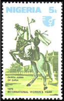
Queen Amina of Zazzau was born around 1533 in the province of Zazzau, in modern-day Nigeria. Zazzau refers to the Zaria emirate which is a traditional state with headquarters in the city of Zaria in Kaduna state in Nigeria. Zazzau was one of the seven Hausa city-states which dominated the subsaharan trade after the collapse of the Songhai Empire at the end of the 16th century. Its wealth was due to the commerce of leather, textile, horses, salt, kola, cloth, and metals imported from the East.
Queen Amina celebrated on a Nigerian stamp
As a toddler, Amina was already attending state business on her grandfather, the king’s laps. At the age of 16, Amina was seen as a potential contender to her mother’s throne (Magajiya), the queen Bakwa of Turunku. Amina started to learn the responsibilities of a queen from her mother: taking part in daily assemblies with high dignitaries of the kingdom. Even though her mother’s reign had been one of peace and prosperity, Amina chose to learn military skills from the warriors.
Queen Bakwa died around 1566, and the Zazzau kingdom was governed by her youngest brother Karama. During the reign of her brother, Amina emerged as principal warrior of the kingdom’s cavalry. Her military successes brought her wealth and power. When her brother died after ten years of reign, Amina was crowned queen of Zazzau in 1576. During her reign, which lasted 34 years, she expanded her kingdom’s boundaries down to the Atlantic coast, she founded several cities, and personally led an army of 20,000 soldiers to numerous battles. However, her focus was not on annexation of neighboring lands, but on forcing local rulers to accept vassal status and allow Hausa traders safe passage.
Portrait of Queen Amina
During her reign, she commanded the construction of a defensive mural around each military camp that she established. Later, those camps evolved into prosperous cities within those walls, and some can still be seen today in northern Nigeria. Those cities are known as walls ‘ganuwar of Amina’ or ‘Amina’s walls‘. It is believed that Amina died in the town of Altagara in 1610. Today, Amina is remembered in Nigeria as ‘Amina, rana de Yar Bakwa ta San’ (Amina, daughter of Nikatau, woman as capable as a man). The introduction of kola nuts into the region is often attributed to Amina. Amina is celebrated across the Hausaland as a great warrior queen who was born to rule, and led thousands of soldiers to war. To learn more, check out Black history heroes, History and Women, as well as the book African Princess which dedicates a chapter to this great queen. Amina’s achievement was the closest that any ruler had come in bringing the region now known as Nigeria under a single authority. Enjoy the video below of great African queens including Amina.
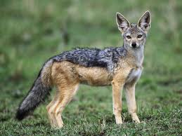
The Sun, it is said, was one day on earth, and the men who were travelling saw him sitting by the wayside, but passed him without notice.
Jackal, however, who came after them, and also sitting, went to him and said, “Such a fine little child is left behind by the men.” He then took Sun up, and put it into this awa-skin (on his back). When it burnt him, he said, “Get down,” and shook himself; but Sun stuck fast to his back, and burnt Jackal’s back black from that day.
South African Folktales, J.A. Honey, 1910, Baker and Taylor Company.
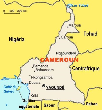
Yaoundé, the capital of Cameroon and its second largest city after Douala, is often known as “the city with the seven hills” because of the hills surrounding it… but what does it really mean? Does its name refer to its hills?
Map of Cameroon, with the capital Yaoundé
In Béti, Yaoundé is often called, Ongolo-Ewondo, or the Ewondos’ enclosure (la clôture des Ewondos). The city was born around 1889, when the German traders implanted a camp in the Ewondo region and called it Sono station after a local Ewondo chief Essono Ela who had offered them hospitality (the Germans had encountered a strong resistance in the Vouté and Eton regions). Hearing locals from the coast refer to it as Ya-Ewondo or Among the Ewondo (chez les Ewondos), the Germans called it ‘Jaunde’ and it later turned into ‘Yaunde’, and in French Yaoundé. The station later turned into an administrative region under the leadership of the botanist Zenker who established a detailed map of the area in 1890. Upon its creation, it was first a scientific post (probably because of the botanist), and later in 1895 became a military and trading post for ivory and rubber.
Yaoundé at night
Yaoundé was not always the country’s capital. After the 1909 volcanic eruption of Mt Cameroon in Buéa (Gbéa) which was then the capital, and the humid climate of Douala, the Germans decided to move the capital to Yaoundé because of its central location and its milder climate (and of course, no volcano). After Germany’s defeat in World War I, Cameroon was placed under French (the eastern regions) and British protectorate (the western regions). Yaoundé consequently became the capital of French Cameroon, and continued as the capital of the Republic of Cameroon after independence (it was first the Federal Republic of Cameroon in 1961, then The United Republic of Cameroon in 1972, which then officially became the Republic of Cameroon in 1984). From 100 inhabitants on 2 acres on land at the end of the 19th century, Yaoundé is today a vibrant city home to almost 2 million inhabitants.
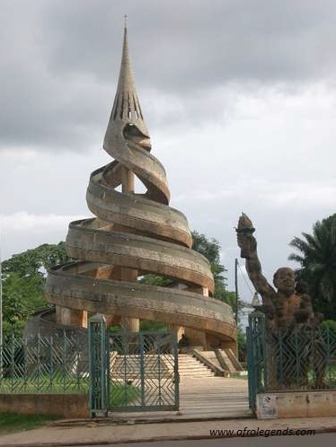
The Reunification Monument in Yaoundé
Yaoundé lies at the center of the nation, at about 600 – 1000 m above sea level. The city first grew around the Mfoundi river. A network of hills make up its landscape such as Mts Mbam Minkom (1295 m), Nkolodom (1221 m), Messa, Fébé, Akokdoué in the North and West, and Mt Eloumden (1159 m) in the south. The rivers are the Mfoundi, Ekozoa, Biyeme, and Mefou. Today, Yaoundé is the siege of power, the presidential palace, the house of parliament, all ministries and embassies. Please enjoy this song of one of Cameroon’s great singers: André-Marie Tala about Yaoundé, and its beauty. What I have always liked about Yaoundé are its hills (and the red soil): from the top of one them, other parts of the city can be seen; it gives a feeling of “breathing in” or “taking in” the beauty of the entire city. Feel the joy of visiting this city which, like Rome has 7 hills. Enjoy the Rome of Africa!